You are here: Home > Network List > TA - USArray Transportable Network (new EarthScope stations) Stations List
> Station S15A Panguitch, AZ, USA > Earthquake Result Viewer
S15A Panguitch, AZ, USA - Earthquake Result Viewer
| Earthquake location: |
Santa Cruz Islands Region |
| Earthquake latitude/longitude: |
-11.0/164.5 |
| Earthquake time(UTC): |
2008/07/19 (201) 09:27:01 GMT |
| Earthquake Depth: |
11 km |
| Earthquake Magnitude: |
6.1 MB, 6.4 MS, 6.6 MW, 6.6 MW |
| Earthquake Catalog/Contributor: |
WHDF/NEIC |
|
| Network: |
TA USArray Transportable Network (new EarthScope stations) |
| Station: |
S15A Panguitch, AZ, USA |
| Lat/Lon: |
37.68 N/112.36 W |
| Elevation: |
2102 m |
|
| Distance: |
91.3 deg |
| Az: |
51.998 deg |
| Baz: |
257.152 deg |
| Ray Param: |
0.04161118 |
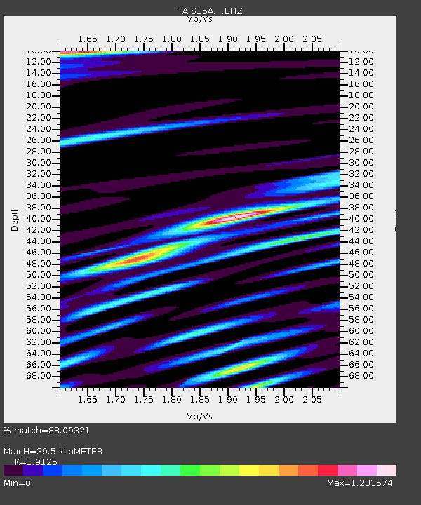
| Estimated Moho Depth: |
39.5 km |
| Estimated Crust Vp/Vs: |
1.91 |
| Assumed Crust Vp: |
6.194 km/s |
| Estimated Crust Vs: |
3.239 km/s |
| Estimated Crust Poisson's Ratio: |
0.31 |
|
| Radial Match: |
88.09321 % |
| Radial Bump: |
400 |
| Transverse Match: |
79.8537 % |
| Transverse Bump: |
400 |
| SOD ConfigId: |
2658 |
| Insert Time: |
2010-03-06 05:31:39.364 +0000 |
| GWidth: |
2.5 |
| Max Bumps: |
400 |
| Tol: |
0.001 |
|

Signal To Noise
| Channel | StoN | STA | LTA |
| TA:S15A: :BHZ:20080719T09:39:35.374001Z | 11.009194 | 1.3971278E-6 | 1.2690555E-7 |
| TA:S15A: :BHN:20080719T09:39:35.374001Z | 1.1176836 | 1.2116315E-7 | 1.08405594E-7 |
| TA:S15A: :BHE:20080719T09:39:35.374001Z | 0.77397174 | 1.209978E-7 | 1.5633361E-7 |
| Arrivals |
| Ps | 5.9 SECOND |
| PpPs | 18 SECOND |
| PsPs/PpSs | 24 SECOND |


