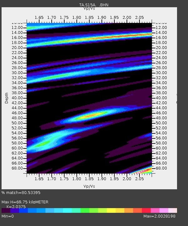
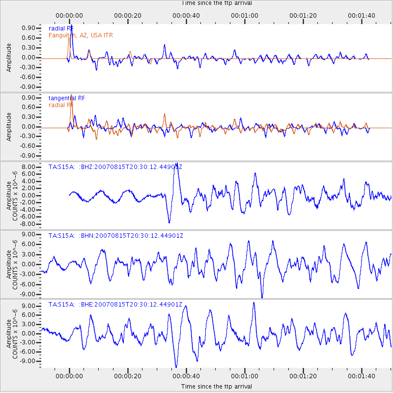
S15A Panguitch, AZ, USA - Earthquake Result Viewer

Earthquake location: Andreanof Islands, Aleutian Is.
Earthquake latitude/longitude: 50.3/-177.5
Earthquake time(UTC): 2007/08/15 (227) 20:22:11 GMT
Earthquake Depth: 9.0 km
Earthquake Magnitude: 6.3 MB, 6.2 MS, 6.4 MW, 5.9 ML
Earthquake Catalog/Contributor: WHDF/NEIC
Network: TA USArray Transportable Network (new EarthScope stations)
Station: S15A Panguitch, AZ, USA
Lat/Lon: 37.68 N/112.36 W
Elevation: 2102 m
Distance: 47.1 deg
Az: 79.418 deg
Baz: 307.427 deg
Ray Param: 0.070211194
Estimated Moho Depth: 69.75 km
Estimated Crust Vp/Vs: 2.04
Assumed Crust Vp: 6.194 km/s
Estimated Crust Vs: 3.04 km/s
Estimated Crust Poisson's Ratio: 0.34
Radial Match: 80.53395 %
Radial Bump: 400
Transverse Match: 56.159893 %
Transverse Bump: 400
SOD ConfigId: 2564
Insert Time: 2010-03-06 05:32:03.675 +0000
GWidth: 2.5
Max Bumps: 400
Tol: 0.001

Signal To Noise

ChannelStoNSTALTA
TA:S15A: :BHN:20070815T20:30:12.44901Z0.54426898.328908E-71.5302929E-6
TA:S15A: :BHE:20070815T20:30:12.44901Z1.38163292.083734E-61.5081675E-6
TA:S15A: :BHZ:20070815T20:30:12.44901Z2.64388662.9046173E-61.0986164E-6
Arrivals
Ps12 SECOND
PpPs33 SECOND
PsPs/PpSs45 SECOND