You are here: Home > Network List > TA - USArray Transportable Network (new EarthScope stations) Stations List
> Station S15A Panguitch, AZ, USA > Earthquake Result Viewer
S15A Panguitch, AZ, USA - Earthquake Result Viewer

| Earthquake location: |
Sea Of Japan |
| Earthquake latitude/longitude: |
36.8/134.9 |
| Earthquake time(UTC): |
2007/07/16 (197) 14:17:37 GMT |
| Earthquake Depth: |
350 km |
| Earthquake Magnitude: |
6.2 MB, 6.8 MW, 6.8 MW |
| Earthquake Catalog/Contributor: |
WHDF/NEIC |
|
| Network: |
TA USArray Transportable Network (new EarthScope stations) |
| Station: |
S15A Panguitch, AZ, USA |
| Lat/Lon: |
37.68 N/112.36 W |
| Elevation: |
2102 m |
|
| Distance: |
83.3 deg |
| Az: |
47.437 deg |
| Baz: |
311.841 deg |
| Ray Param: |
0.045354545 |
| Estimated Moho Depth: |
10.0 km |
| Estimated Crust Vp/Vs: |
1.60 |
| Assumed Crust Vp: |
6.194 km/s |
| Estimated Crust Vs: |
3.871 km/s |
| Estimated Crust Poisson's Ratio: |
0.18 |
|
| Radial Match: |
89.255035 % |
| Radial Bump: |
400 |
| Transverse Match: |
71.78037 % |
| Transverse Bump: |
400 |
| SOD ConfigId: |
2564 |
| Insert Time: |
2010-03-06 05:32:09.587 +0000 |
| GWidth: |
2.5 |
| Max Bumps: |
400 |
| Tol: |
0.001 |
|
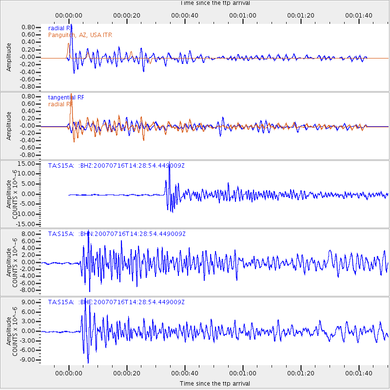
Signal To Noise
| Channel | StoN | STA | LTA |
| TA:S15A: :BHN:20070716T14:28:54.449009Z | 5.1978602 | 8.865649E-7 | 1.7056344E-7 |
| TA:S15A: :BHE:20070716T14:28:54.449009Z | 8.806163 | 1.2200763E-6 | 1.38548E-7 |
| TA:S15A: :BHZ:20070716T14:28:54.449009Z | 34.330627 | 4.259117E-6 | 1.2406173E-7 |
| Arrivals |
| Ps | 1.0 SECOND |
| PpPs | 4.1 SECOND |
| PsPs/PpSs | 5.1 SECOND |


