You are here: Home > Network List > LD - Lamont-Doherty Cooperative Seismographic Network Stations List
> Station FMMC Franklin & Marshall College/Millport Conservancy, PA > Earthquake Result Viewer
FMMC Franklin & Marshall College/Millport Conservancy, PA - Earthquake Result Viewer
| Earthquake location: |
North Of Franz Josef Land |
| Earthquake latitude/longitude: |
86.9/55.1 |
| Earthquake time(UTC): |
2017/10/28 (301) 19:11:01 GMT |
| Earthquake Depth: |
10 km |
| Earthquake Magnitude: |
6.0 Mww |
| Earthquake Catalog/Contributor: |
NEIC PDE/us |
|
| Network: |
LD Lamont-Doherty Cooperative Seismographic Network |
| Station: |
FMMC Franklin & Marshall College/Millport Conservancy, PA |
| Lat/Lon: |
40.14 N/76.26 W |
| Elevation: |
101 m |
|
| Distance: |
52.2 deg |
| Az: |
313.259 deg |
| Baz: |
2.971 deg |
| Ray Param: |
0.06693823 |
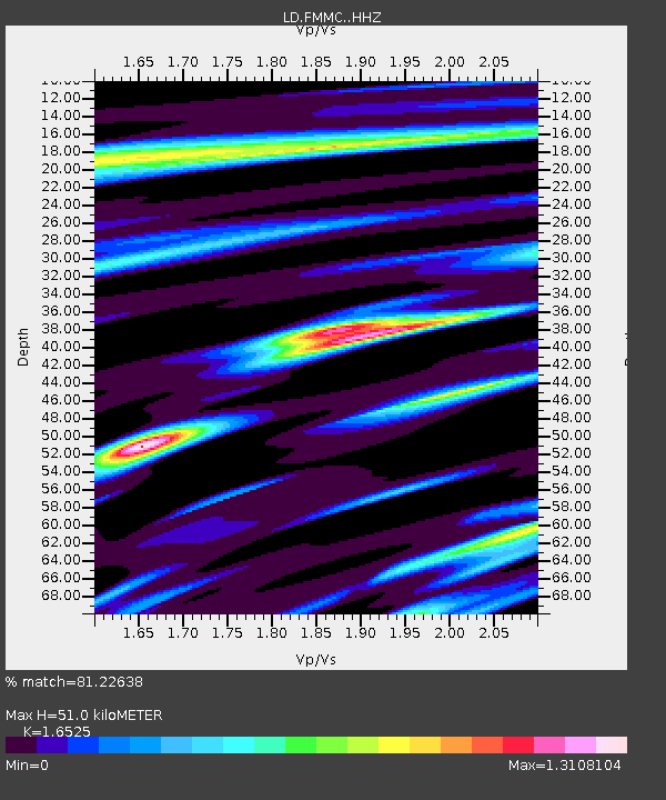
| Estimated Moho Depth: |
51.0 km |
| Estimated Crust Vp/Vs: |
1.65 |
| Assumed Crust Vp: |
6.121 km/s |
| Estimated Crust Vs: |
3.704 km/s |
| Estimated Crust Poisson's Ratio: |
0.21 |
|
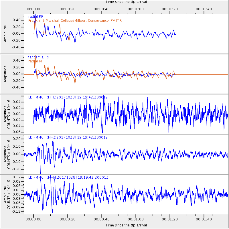
| Radial Match: |
81.22638 % |
| Radial Bump: |
400 |
| Transverse Match: |
68.12523 % |
| Transverse Bump: |
400 |
| SOD ConfigId: |
13570011 |
| Insert Time: |
2019-04-29 00:57:36.719 +0000 |
| GWidth: |
2.5 |
| Max Bumps: |
400 |
| Tol: |
0.001 |
|
Signal To Noise
| Channel | StoN | STA | LTA |
| LD:FMMC: :HHZ:20171028T19:19:42.20001Z | 5.360363 | 8.195894E-8 | 1.5289812E-8 |
| LD:FMMC: :HHN:20171028T19:19:42.20001Z | 2.6671782 | 4.0400288E-8 | 1.5147203E-8 |
| LD:FMMC: :HHE:20171028T19:19:42.20001Z | 1.7191634 | 2.2847308E-8 | 1.3289783E-8 |
| Arrivals |
| Ps | 5.7 SECOND |
| PpPs | 21 SECOND |
| PsPs/PpSs | 27 SECOND |


