You are here: Home > Network List > N4 - Central and EAstern US Network Stations List
> Station N49A Columbus Grove, OH, USA > Earthquake Result Viewer
N49A Columbus Grove, OH, USA - Earthquake Result Viewer
| Earthquake location: |
North Of Franz Josef Land |
| Earthquake latitude/longitude: |
86.9/55.1 |
| Earthquake time(UTC): |
2017/10/28 (301) 19:11:01 GMT |
| Earthquake Depth: |
10 km |
| Earthquake Magnitude: |
6.0 Mww |
| Earthquake Catalog/Contributor: |
NEIC PDE/us |
|
| Network: |
N4 Central and EAstern US Network |
| Station: |
N49A Columbus Grove, OH, USA |
| Lat/Lon: |
40.92 N/84.18 W |
| Elevation: |
225 m |
|
| Distance: |
51.7 deg |
| Az: |
320.972 deg |
| Baz: |
2.599 deg |
| Ray Param: |
0.067262396 |
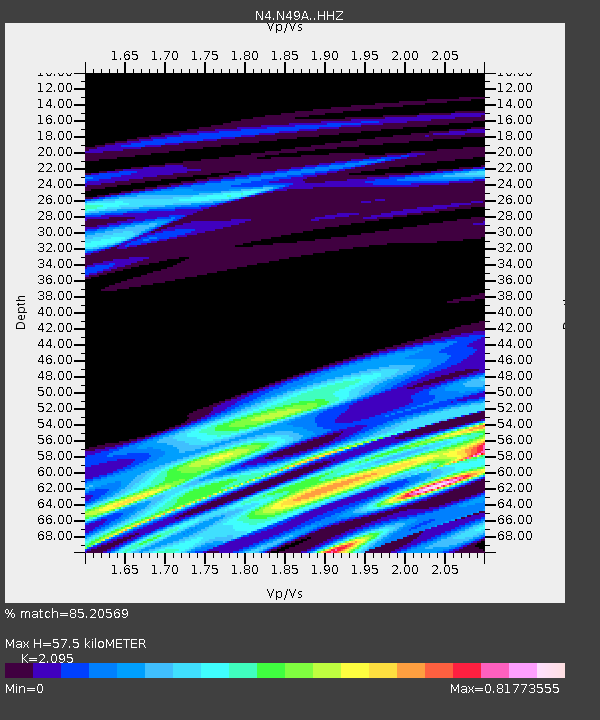
| Estimated Moho Depth: |
57.5 km |
| Estimated Crust Vp/Vs: |
2.10 |
| Assumed Crust Vp: |
6.498 km/s |
| Estimated Crust Vs: |
3.101 km/s |
| Estimated Crust Poisson's Ratio: |
0.35 |
|
| Radial Match: |
85.20569 % |
| Radial Bump: |
327 |
| Transverse Match: |
70.14236 % |
| Transverse Bump: |
400 |
| SOD ConfigId: |
13570011 |
| Insert Time: |
2019-04-29 00:59:07.439 +0000 |
| GWidth: |
2.5 |
| Max Bumps: |
400 |
| Tol: |
0.001 |
|

Signal To Noise
| Channel | StoN | STA | LTA |
| N4:N49A: :HHZ:20171028T19:19:38.539976Z | 2.4701982 | 8.868019E-7 | 3.590003E-7 |
| N4:N49A: :HHN:20171028T19:19:38.539976Z | 2.6400206 | 7.7258306E-7 | 2.926428E-7 |
| N4:N49A: :HHE:20171028T19:19:38.539976Z | 1.0418574 | 1.8428813E-7 | 1.7688423E-7 |
| Arrivals |
| Ps | 10 SECOND |
| PpPs | 26 SECOND |
| PsPs/PpSs | 36 SECOND |


