You are here: Home > Network List > TA - USArray Transportable Network (new EarthScope stations) Stations List
> Station S15A Panguitch, AZ, USA > Earthquake Result Viewer
S15A Panguitch, AZ, USA - Earthquake Result Viewer
*The percent match for this event was below the threshold and hence no stack was calculated.
| Earthquake location: |
Ryukyu Islands, Japan |
| Earthquake latitude/longitude: |
27.5/128.3 |
| Earthquake time(UTC): |
2008/07/08 (190) 07:42:10 GMT |
| Earthquake Depth: |
43 km |
| Earthquake Magnitude: |
6.0 MB, 5.5 MS, 6.0 MW, 6.0 MW |
| Earthquake Catalog/Contributor: |
WHDF/NEIC |
|
| Network: |
TA USArray Transportable Network (new EarthScope stations) |
| Station: |
S15A Panguitch, AZ, USA |
| Lat/Lon: |
37.68 N/112.36 W |
| Elevation: |
2102 m |
|
| Distance: |
93.7 deg |
| Az: |
43.899 deg |
| Baz: |
309.101 deg |
| Ray Param: |
$rayparam |
*The percent match for this event was below the threshold and hence was not used in the summary stack. |
|
| Radial Match: |
54.860405 % |
| Radial Bump: |
400 |
| Transverse Match: |
65.86314 % |
| Transverse Bump: |
400 |
| SOD ConfigId: |
2504 |
| Insert Time: |
2010-03-06 05:32:40.782 +0000 |
| GWidth: |
2.5 |
| Max Bumps: |
400 |
| Tol: |
0.001 |
|
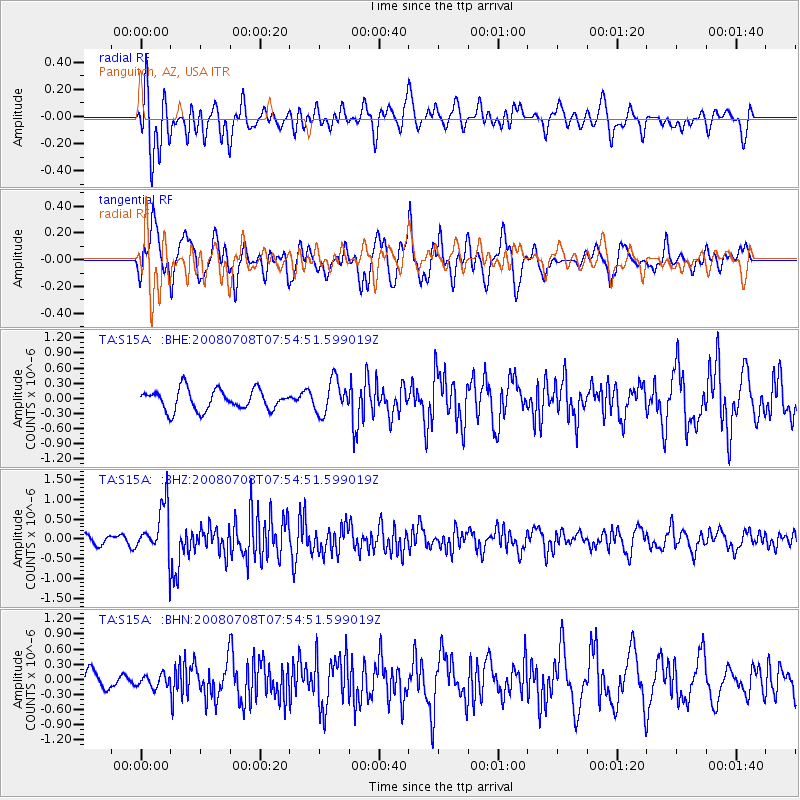
Signal To Noise
| Channel | StoN | STA | LTA |
| TA:S15A: :BHZ:20080708T07:54:51.599019Z | 3.3229413 | 6.3083644E-7 | 1.8984278E-7 |
| TA:S15A: :BHN:20080708T07:54:51.599019Z | 0.5355029 | 1.2720513E-7 | 2.3754329E-7 |
| TA:S15A: :BHE:20080708T07:54:51.599019Z | 1.6266425 | 3.28277E-7 | 2.0181264E-7 |
| Arrivals |
| Ps | |
| PpPs | |
| PsPs/PpSs | |


