You are here: Home > Network List > TA - USArray Transportable Network (new EarthScope stations) Stations List
> Station S15A Panguitch, AZ, USA > Earthquake Result Viewer
S15A Panguitch, AZ, USA - Earthquake Result Viewer
*The percent match for this event was below the threshold and hence no stack was calculated.
| Earthquake location: |
Near East Coast Of Kamchatka |
| Earthquake latitude/longitude: |
51.9/158.4 |
| Earthquake time(UTC): |
2008/09/18 (262) 11:58:50 GMT |
| Earthquake Depth: |
67 km |
| Earthquake Magnitude: |
5.7 MB, 5.9 MW, 5.8 MW |
| Earthquake Catalog/Contributor: |
WHDF/NEIC |
|
| Network: |
TA USArray Transportable Network (new EarthScope stations) |
| Station: |
S15A Panguitch, AZ, USA |
| Lat/Lon: |
37.68 N/112.36 W |
| Elevation: |
2102 m |
|
| Distance: |
61.0 deg |
| Az: |
65.069 deg |
| Baz: |
314.943 deg |
| Ray Param: |
$rayparam |
*The percent match for this event was below the threshold and hence was not used in the summary stack. |
|
| Radial Match: |
63.674988 % |
| Radial Bump: |
400 |
| Transverse Match: |
66.43509 % |
| Transverse Bump: |
400 |
| SOD ConfigId: |
2560 |
| Insert Time: |
2010-03-06 05:32:44.750 +0000 |
| GWidth: |
2.5 |
| Max Bumps: |
400 |
| Tol: |
0.001 |
|
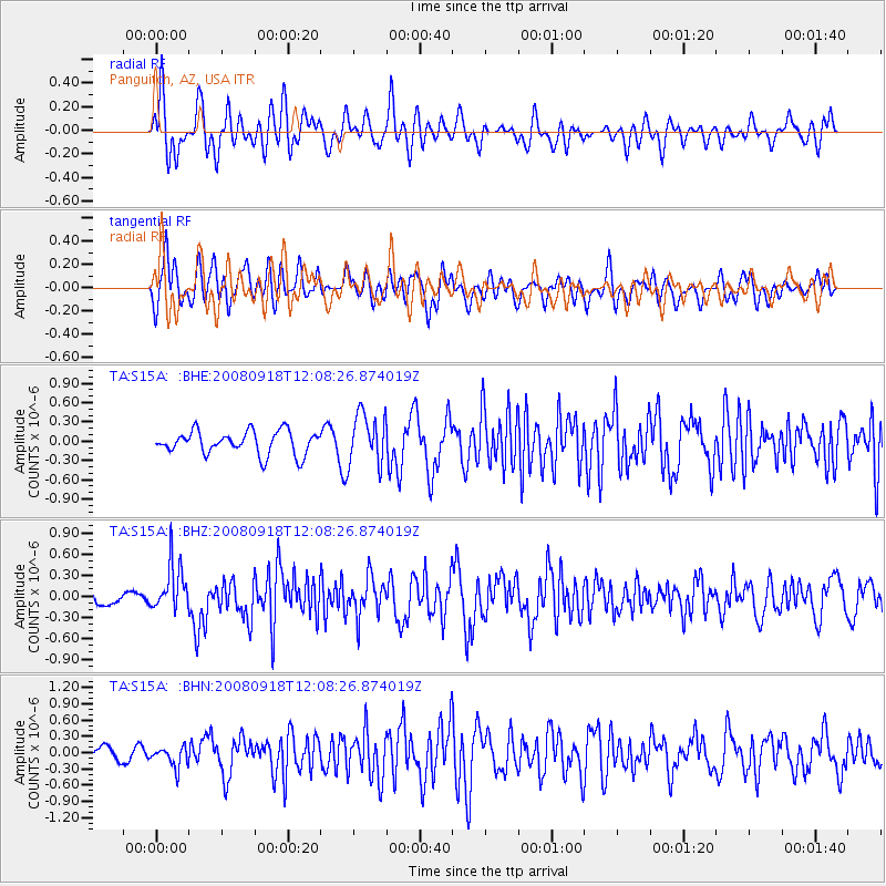
Signal To Noise
| Channel | StoN | STA | LTA |
| TA:S15A: :BHZ:20080918T12:08:26.874019Z | 2.6694946 | 3.355712E-7 | 1.2570588E-7 |
| TA:S15A: :BHN:20080918T12:08:26.874019Z | 0.9731198 | 1.8083584E-7 | 1.8583101E-7 |
| TA:S15A: :BHE:20080918T12:08:26.874019Z | 2.1791782 | 3.9254957E-7 | 1.8013651E-7 |
| Arrivals |
| Ps | |
| PpPs | |
| PsPs/PpSs | |


