You are here: Home > Network List > TA - USArray Transportable Network (new EarthScope stations) Stations List
> Station S15A Panguitch, AZ, USA > Earthquake Result Viewer
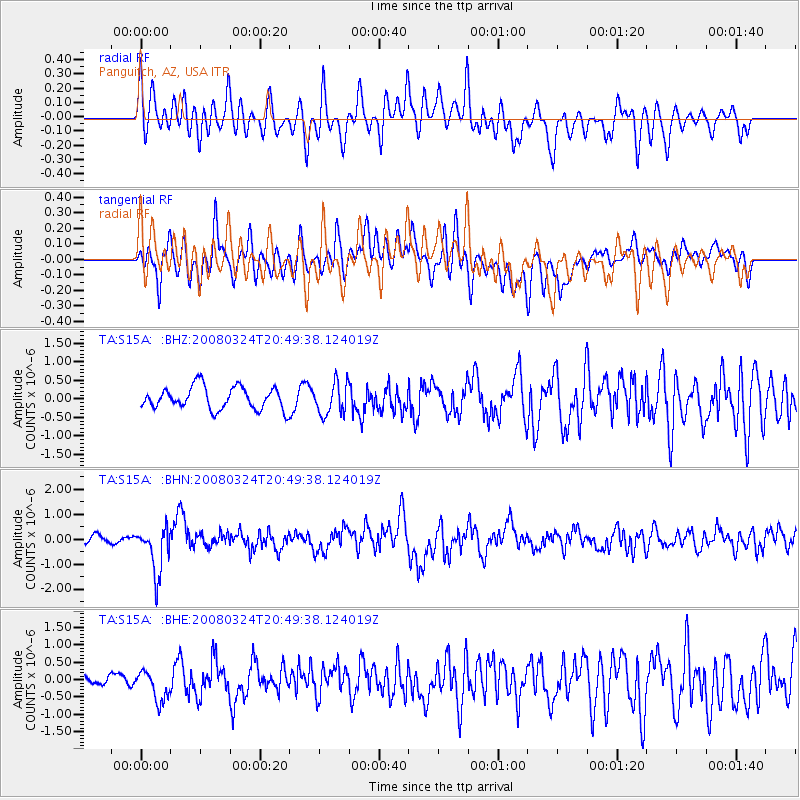
S15A Panguitch, AZ, USA - Earthquake Result Viewer
*The percent match for this event was below the threshold and hence no stack was calculated.
| Earthquake location: |
Chile-Bolivia Border Region |
| Earthquake latitude/longitude: |
-20.0/-69.0 |
| Earthquake time(UTC): |
2008/03/24 (084) 20:39:07 GMT |
| Earthquake Depth: |
120 km |
| Earthquake Magnitude: |
5.7 MB, 6.2 MW, 6.1 MW |
| Earthquake Catalog/Contributor: |
WHDF/NEIC |
|
| Network: |
TA USArray Transportable Network (new EarthScope stations) |
| Station: |
S15A Panguitch, AZ, USA |
| Lat/Lon: |
37.68 N/112.36 W |
| Elevation: |
2102 m |
|
| Distance: |
70.4 deg |
| Az: |
324.653 deg |
| Baz: |
136.725 deg |
| Ray Param: |
$rayparam |
*The percent match for this event was below the threshold and hence was not used in the summary stack. |
|
| Radial Match: |
66.62905 % |
| Radial Bump: |
400 |
| Transverse Match: |
66.13518 % |
| Transverse Bump: |
400 |
| SOD ConfigId: |
2504 |
| Insert Time: |
2010-03-06 05:32:53.829 +0000 |
| GWidth: |
2.5 |
| Max Bumps: |
400 |
| Tol: |
0.001 |
|
Signal To Noise
| Channel | StoN | STA | LTA |
| TA:S15A: :BHN:20080324T20:49:38.124019Z | 4.326592 | 9.330227E-7 | 2.1564841E-7 |
| TA:S15A: :BHE:20080324T20:49:38.124019Z | 1.8214097 | 4.7052853E-7 | 2.5833205E-7 |
| TA:S15A: :BHZ:20080324T20:49:38.124019Z | 1.4520644 | 4.353936E-7 | 2.9984454E-7 |
| Arrivals |
| Ps | |
| PpPs | |
| PsPs/PpSs | |


