You are here: Home > Network List > TA - USArray Transportable Network (new EarthScope stations) Stations List
> Station S15A Panguitch, AZ, USA > Earthquake Result Viewer
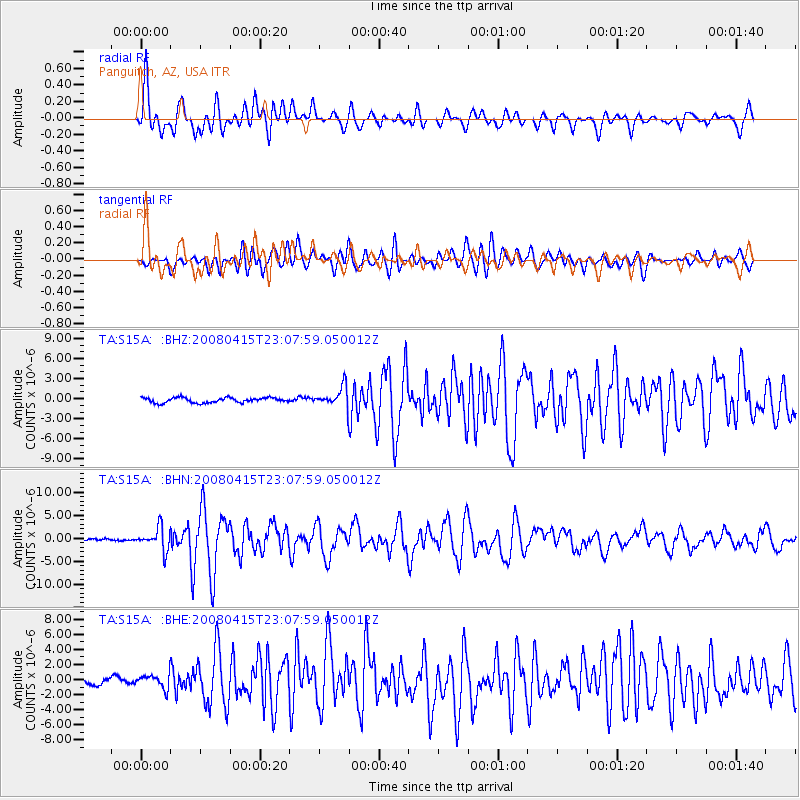
S15A Panguitch, AZ, USA - Earthquake Result Viewer
*The percent match for this event was below the threshold and hence no stack was calculated.
| Earthquake location: |
Andreanof Islands, Aleutian Is. |
| Earthquake latitude/longitude: |
51.9/-179.4 |
| Earthquake time(UTC): |
2008/04/15 (106) 22:59:51 GMT |
| Earthquake Depth: |
10 km |
| Earthquake Magnitude: |
6.1 MB, 6.4 MS, 6.4 MW, 6.4 MW |
| Earthquake Catalog/Contributor: |
WHDF/NEIC |
|
| Network: |
TA USArray Transportable Network (new EarthScope stations) |
| Station: |
S15A Panguitch, AZ, USA |
| Lat/Lon: |
37.68 N/112.36 W |
| Elevation: |
2102 m |
|
| Distance: |
48.0 deg |
| Az: |
79.585 deg |
| Baz: |
309.754 deg |
| Ray Param: |
$rayparam |
*The percent match for this event was below the threshold and hence was not used in the summary stack. |
|
| Radial Match: |
75.21779 % |
| Radial Bump: |
400 |
| Transverse Match: |
77.52131 % |
| Transverse Bump: |
400 |
| SOD ConfigId: |
2504 |
| Insert Time: |
2010-03-06 05:32:55.733 +0000 |
| GWidth: |
2.5 |
| Max Bumps: |
400 |
| Tol: |
0.001 |
|
Signal To Noise
| Channel | StoN | STA | LTA |
| TA:S15A: :BHN:20080415T23:07:59.050012Z | 11.474154 | 2.436529E-6 | 2.1234933E-7 |
| TA:S15A: :BHE:20080415T23:07:59.050012Z | 1.8666886 | 1.0119913E-6 | 5.4213183E-7 |
| TA:S15A: :BHZ:20080415T23:07:59.050012Z | 4.1231 | 1.5231093E-6 | 3.694088E-7 |
| Arrivals |
| Ps | |
| PpPs | |
| PsPs/PpSs | |


