You are here: Home > Network List > TA - USArray Transportable Network (new EarthScope stations) Stations List
> Station S15A Panguitch, AZ, USA > Earthquake Result Viewer
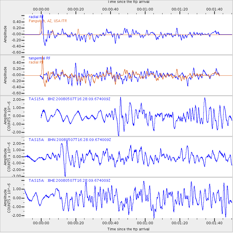
S15A Panguitch, AZ, USA - Earthquake Result Viewer
*The percent match for this event was below the threshold and hence no stack was calculated.
| Earthquake location: |
Near East Coast Of Honshu, Japan |
| Earthquake latitude/longitude: |
36.2/141.8 |
| Earthquake time(UTC): |
2008/05/07 (128) 16:16:36 GMT |
| Earthquake Depth: |
23 km |
| Earthquake Magnitude: |
5.9 MB, 6.1 MW, 6.0 MW |
| Earthquake Catalog/Contributor: |
WHDF/NEIC |
|
| Network: |
TA USArray Transportable Network (new EarthScope stations) |
| Station: |
S15A Panguitch, AZ, USA |
| Lat/Lon: |
37.68 N/112.36 W |
| Elevation: |
2102 m |
|
| Distance: |
79.5 deg |
| Az: |
50.905 deg |
| Baz: |
307.665 deg |
| Ray Param: |
$rayparam |
*The percent match for this event was below the threshold and hence was not used in the summary stack. |
|
| Radial Match: |
70.72312 % |
| Radial Bump: |
400 |
| Transverse Match: |
61.090714 % |
| Transverse Bump: |
400 |
| SOD ConfigId: |
2504 |
| Insert Time: |
2010-03-06 05:33:03.133 +0000 |
| GWidth: |
2.5 |
| Max Bumps: |
400 |
| Tol: |
0.001 |
|
Signal To Noise
| Channel | StoN | STA | LTA |
| TA:S15A: :BHN:20080507T16:28:09.674009Z | 1.4448305 | 2.6289922E-7 | 1.8195851E-7 |
| TA:S15A: :BHE:20080507T16:28:09.674009Z | 0.7516548 | 4.5125248E-7 | 6.0034534E-7 |
| TA:S15A: :BHZ:20080507T16:28:09.674009Z | 0.82951415 | 3.7587043E-7 | 4.5312117E-7 |
| Arrivals |
| Ps | |
| PpPs | |
| PsPs/PpSs | |


