You are here: Home > Network List > TA - USArray Transportable Network (new EarthScope stations) Stations List
> Station S15A Panguitch, AZ, USA > Earthquake Result Viewer
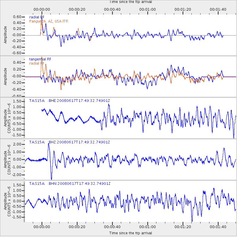
S15A Panguitch, AZ, USA - Earthquake Result Viewer
*The percent match for this event was below the threshold and hence no stack was calculated.
| Earthquake location: |
South Of Panama |
| Earthquake latitude/longitude: |
5.0/-82.7 |
| Earthquake time(UTC): |
2008/06/17 (169) 17:42:09 GMT |
| Earthquake Depth: |
10 km |
| Earthquake Magnitude: |
5.6 MB, 5.3 MS, 5.9 MW, 5.9 MW |
| Earthquake Catalog/Contributor: |
WHDF/NEIC |
|
| Network: |
TA USArray Transportable Network (new EarthScope stations) |
| Station: |
S15A Panguitch, AZ, USA |
| Lat/Lon: |
37.68 N/112.36 W |
| Elevation: |
2102 m |
|
| Distance: |
42.3 deg |
| Az: |
324.265 deg |
| Baz: |
132.837 deg |
| Ray Param: |
$rayparam |
*The percent match for this event was below the threshold and hence was not used in the summary stack. |
|
| Radial Match: |
66.97536 % |
| Radial Bump: |
400 |
| Transverse Match: |
58.756855 % |
| Transverse Bump: |
400 |
| SOD ConfigId: |
2504 |
| Insert Time: |
2010-03-06 05:33:18.161 +0000 |
| GWidth: |
2.5 |
| Max Bumps: |
400 |
| Tol: |
0.001 |
|
Signal To Noise
| Channel | StoN | STA | LTA |
| TA:S15A: :BHZ:20080617T17:49:32.74901Z | 7.0508766 | 7.629568E-7 | 1.0820737E-7 |
| TA:S15A: :BHN:20080617T17:49:32.74901Z | 0.5338335 | 1.7947956E-7 | 3.3620884E-7 |
| TA:S15A: :BHE:20080617T17:49:32.74901Z | 1.3741219 | 4.882332E-7 | 3.553056E-7 |
| Arrivals |
| Ps | |
| PpPs | |
| PsPs/PpSs | |


