You are here: Home > Network List > TA - USArray Transportable Network (new EarthScope stations) Stations List
> Station K22A Casper, WY, USA > Earthquake Result Viewer
K22A Casper, WY, USA - Earthquake Result Viewer
*The percent match for this event was below the threshold and hence no stack was calculated.
| Earthquake location: |
North Of Franz Josef Land |
| Earthquake latitude/longitude: |
86.9/55.1 |
| Earthquake time(UTC): |
2017/10/28 (301) 19:11:01 GMT |
| Earthquake Depth: |
10 km |
| Earthquake Magnitude: |
6.0 Mww |
| Earthquake Catalog/Contributor: |
NEIC PDE/us |
|
| Network: |
TA USArray Transportable Network (new EarthScope stations) |
| Station: |
K22A Casper, WY, USA |
| Lat/Lon: |
42.65 N/106.52 W |
| Elevation: |
1686 m |
|
| Distance: |
50.5 deg |
| Az: |
342.495 deg |
| Baz: |
1.275 deg |
| Ray Param: |
$rayparam |
*The percent match for this event was below the threshold and hence was not used in the summary stack. |
|
| Radial Match: |
70.18601 % |
| Radial Bump: |
375 |
| Transverse Match: |
63.041416 % |
| Transverse Bump: |
400 |
| SOD ConfigId: |
13570011 |
| Insert Time: |
2019-04-29 01:02:09.584 +0000 |
| GWidth: |
2.5 |
| Max Bumps: |
400 |
| Tol: |
0.001 |
|
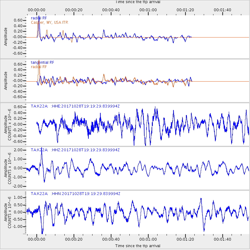
Signal To Noise
| Channel | StoN | STA | LTA |
| TA:K22A: :HHZ:20171028T19:19:29.839994Z | 4.769855 | 8.2635023E-7 | 1.732443E-7 |
| TA:K22A: :HHN:20171028T19:19:29.839994Z | 2.502051 | 6.0104753E-7 | 2.402219E-7 |
| TA:K22A: :HHE:20171028T19:19:29.839994Z | 0.9943277 | 1.6933022E-7 | 1.702962E-7 |
| Arrivals |
| Ps | |
| PpPs | |
| PsPs/PpSs | |


