You are here: Home > Network List > TA - USArray Transportable Network (new EarthScope stations) Stations List
> Station M26K Nabesna, AK, USA > Earthquake Result Viewer
M26K Nabesna, AK, USA - Earthquake Result Viewer
| Earthquake location: |
North Of Franz Josef Land |
| Earthquake latitude/longitude: |
86.9/55.1 |
| Earthquake time(UTC): |
2017/10/28 (301) 19:11:01 GMT |
| Earthquake Depth: |
10 km |
| Earthquake Magnitude: |
6.0 Mww |
| Earthquake Catalog/Contributor: |
NEIC PDE/us |
|
| Network: |
TA USArray Transportable Network (new EarthScope stations) |
| Station: |
M26K Nabesna, AK, USA |
| Lat/Lon: |
62.40 N/143.00 W |
| Elevation: |
888 m |
|
| Distance: |
30.7 deg |
| Az: |
16.47 deg |
| Baz: |
358.097 deg |
| Ray Param: |
0.07925179 |
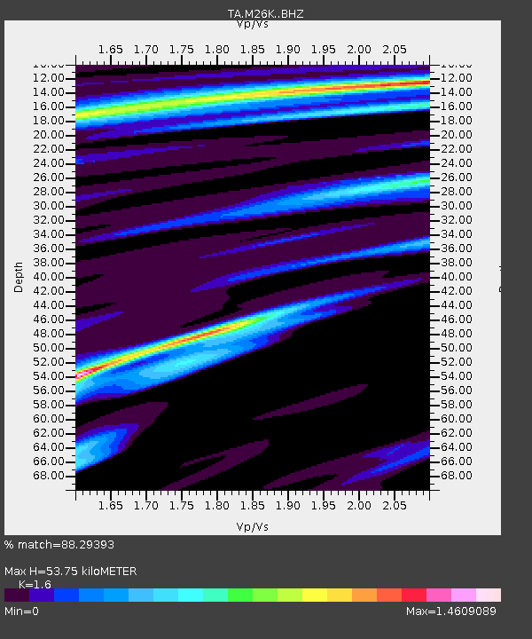
| Estimated Moho Depth: |
53.75 km |
| Estimated Crust Vp/Vs: |
1.60 |
| Assumed Crust Vp: |
6.566 km/s |
| Estimated Crust Vs: |
4.104 km/s |
| Estimated Crust Poisson's Ratio: |
0.18 |
|
| Radial Match: |
88.29393 % |
| Radial Bump: |
302 |
| Transverse Match: |
64.27756 % |
| Transverse Bump: |
339 |
| SOD ConfigId: |
13570011 |
| Insert Time: |
2019-04-29 01:02:25.733 +0000 |
| GWidth: |
2.5 |
| Max Bumps: |
400 |
| Tol: |
0.001 |
|

Signal To Noise
| Channel | StoN | STA | LTA |
| TA:M26K: :BHZ:20171028T19:16:47.100004Z | 2.7671332 | 7.167438E-7 | 2.590203E-7 |
| TA:M26K: :BHN:20171028T19:16:47.100004Z | 2.5787954 | 4.489983E-7 | 1.7411163E-7 |
| TA:M26K: :BHE:20171028T19:16:47.100004Z | 0.717933 | 1.1872779E-7 | 1.6537447E-7 |
| Arrivals |
| Ps | 5.4 SECOND |
| PpPs | 19 SECOND |
| PsPs/PpSs | 25 SECOND |


