You are here: Home > Network List > TA - USArray Transportable Network (new EarthScope stations) Stations List
> Station M30M Minto, Yukon, CA > Earthquake Result Viewer
M30M Minto, Yukon, CA - Earthquake Result Viewer
| Earthquake location: |
North Of Franz Josef Land |
| Earthquake latitude/longitude: |
86.9/55.1 |
| Earthquake time(UTC): |
2017/10/28 (301) 19:11:01 GMT |
| Earthquake Depth: |
10 km |
| Earthquake Magnitude: |
6.0 Mww |
| Earthquake Catalog/Contributor: |
NEIC PDE/us |
|
| Network: |
TA USArray Transportable Network (new EarthScope stations) |
| Station: |
M30M Minto, Yukon, CA |
| Lat/Lon: |
62.58 N/136.79 W |
| Elevation: |
782 m |
|
| Distance: |
30.6 deg |
| Az: |
10.82 deg |
| Baz: |
358.732 deg |
| Ray Param: |
0.07927696 |
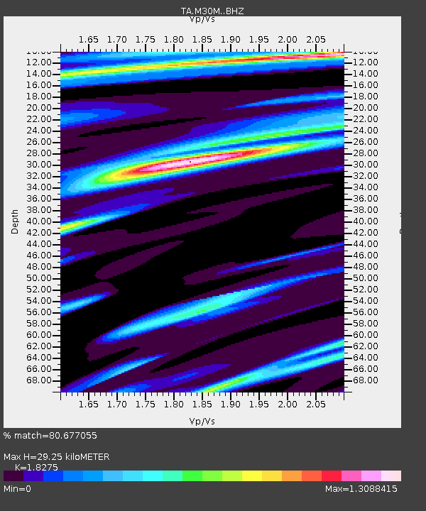
| Estimated Moho Depth: |
29.25 km |
| Estimated Crust Vp/Vs: |
1.83 |
| Assumed Crust Vp: |
6.566 km/s |
| Estimated Crust Vs: |
3.593 km/s |
| Estimated Crust Poisson's Ratio: |
0.29 |
|
| Radial Match: |
80.677055 % |
| Radial Bump: |
285 |
| Transverse Match: |
60.05998 % |
| Transverse Bump: |
400 |
| SOD ConfigId: |
13570011 |
| Insert Time: |
2019-04-29 01:02:28.253 +0000 |
| GWidth: |
2.5 |
| Max Bumps: |
400 |
| Tol: |
0.001 |
|

Signal To Noise
| Channel | StoN | STA | LTA |
| TA:M30M: :BHZ:20171028T19:16:46.274991Z | 3.938595 | 8.9124313E-7 | 2.2628451E-7 |
| TA:M30M: :BHN:20171028T19:16:46.274991Z | 3.7635372 | 6.136245E-7 | 1.6304462E-7 |
| TA:M30M: :BHE:20171028T19:16:46.274991Z | 0.7536648 | 2.2013641E-7 | 2.9208795E-7 |
| Arrivals |
| Ps | 4.0 SECOND |
| PpPs | 12 SECOND |
| PsPs/PpSs | 16 SECOND |


