You are here: Home > Network List > TA - USArray Transportable Network (new EarthScope stations) Stations List
> Station O17K Koliganek, Bristol Bay, AK, USA > Earthquake Result Viewer
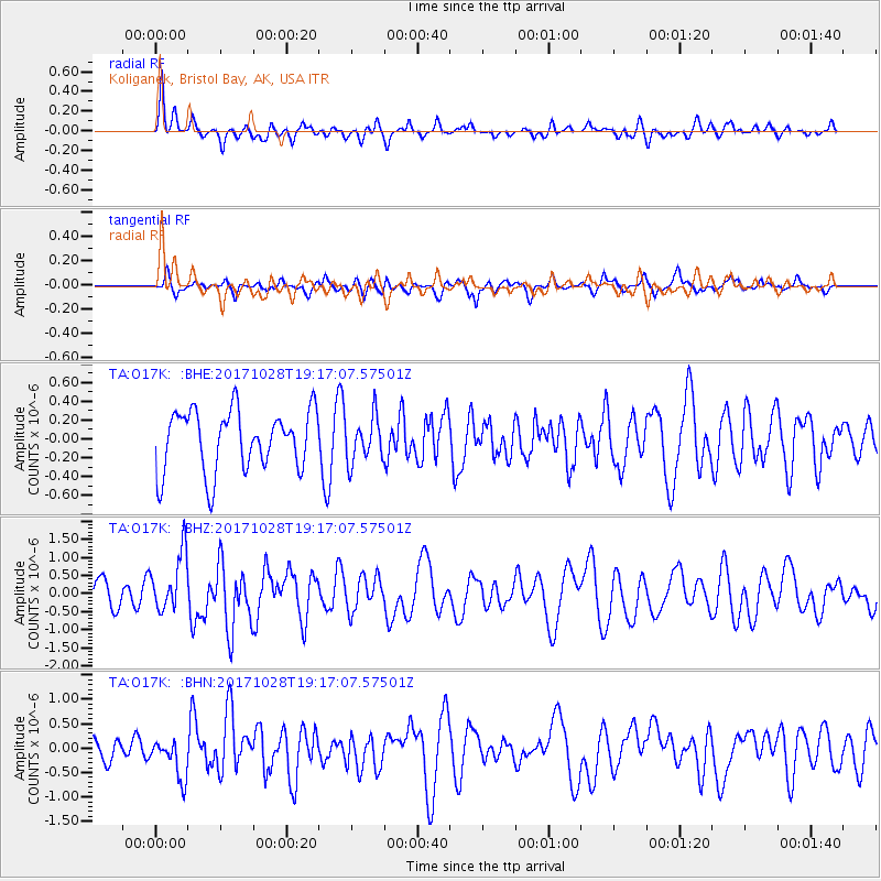
O17K Koliganek, Bristol Bay, AK, USA - Earthquake Result Viewer
*The percent match for this event was below the threshold and hence no stack was calculated.
| Earthquake location: |
North Of Franz Josef Land |
| Earthquake latitude/longitude: |
86.9/55.1 |
| Earthquake time(UTC): |
2017/10/28 (301) 19:11:01 GMT |
| Earthquake Depth: |
10 km |
| Earthquake Magnitude: |
6.0 Mww |
| Earthquake Catalog/Contributor: |
NEIC PDE/us |
|
| Network: |
TA USArray Transportable Network (new EarthScope stations) |
| Station: |
O17K Koliganek, Bristol Bay, AK, USA |
| Lat/Lon: |
59.77 N/157.09 W |
| Elevation: |
156 m |
|
| Distance: |
33.1 deg |
| Az: |
29.629 deg |
| Baz: |
356.944 deg |
| Ray Param: |
$rayparam |
*The percent match for this event was below the threshold and hence was not used in the summary stack. |
|
| Radial Match: |
69.46121 % |
| Radial Bump: |
400 |
| Transverse Match: |
53.31512 % |
| Transverse Bump: |
400 |
| SOD ConfigId: |
13570011 |
| Insert Time: |
2019-04-29 01:02:43.213 +0000 |
| GWidth: |
2.5 |
| Max Bumps: |
400 |
| Tol: |
0.001 |
|
Signal To Noise
| Channel | StoN | STA | LTA |
| TA:O17K: :BHZ:20171028T19:17:07.57501Z | 2.198 | 8.0779176E-7 | 3.6751217E-7 |
| TA:O17K: :BHN:20171028T19:17:07.57501Z | 1.414393 | 4.0207152E-7 | 2.8427144E-7 |
| TA:O17K: :BHE:20171028T19:17:07.57501Z | 0.90570456 | 2.8789898E-7 | 3.1787295E-7 |
| Arrivals |
| Ps | |
| PpPs | |
| PsPs/PpSs | |


