You are here: Home > Network List > TA - USArray Transportable Network (new EarthScope stations) Stations List
> Station P32M Atlin, BC, CAN > Earthquake Result Viewer
P32M Atlin, BC, CAN - Earthquake Result Viewer
| Earthquake location: |
North Of Franz Josef Land |
| Earthquake latitude/longitude: |
86.9/55.1 |
| Earthquake time(UTC): |
2017/10/28 (301) 19:11:01 GMT |
| Earthquake Depth: |
10 km |
| Earthquake Magnitude: |
6.0 Mww |
| Earthquake Catalog/Contributor: |
NEIC PDE/us |
|
| Network: |
TA USArray Transportable Network (new EarthScope stations) |
| Station: |
P32M Atlin, BC, CAN |
| Lat/Lon: |
59.59 N/133.71 W |
| Elevation: |
793 m |
|
| Distance: |
33.7 deg |
| Az: |
8.115 deg |
| Baz: |
359.133 deg |
| Ray Param: |
0.07809979 |
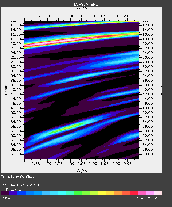
| Estimated Moho Depth: |
18.75 km |
| Estimated Crust Vp/Vs: |
1.75 |
| Assumed Crust Vp: |
6.597 km/s |
| Estimated Crust Vs: |
3.781 km/s |
| Estimated Crust Poisson's Ratio: |
0.26 |
|
| Radial Match: |
80.3616 % |
| Radial Bump: |
400 |
| Transverse Match: |
52.65397 % |
| Transverse Bump: |
393 |
| SOD ConfigId: |
13570011 |
| Insert Time: |
2019-04-29 01:02:56.578 +0000 |
| GWidth: |
2.5 |
| Max Bumps: |
400 |
| Tol: |
0.001 |
|
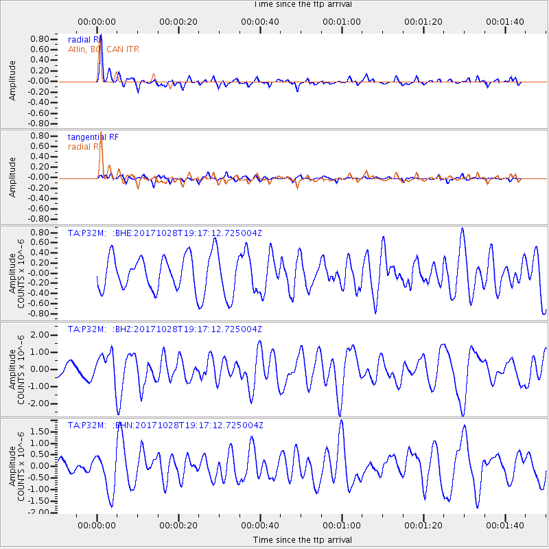
Signal To Noise
| Channel | StoN | STA | LTA |
| TA:P32M: :BHZ:20171028T19:17:12.725004Z | 2.703505 | 9.122934E-7 | 3.374484E-7 |
| TA:P32M: :BHN:20171028T19:17:12.725004Z | 3.844927 | 8.8069396E-7 | 2.290535E-7 |
| TA:P32M: :BHE:20171028T19:17:12.725004Z | 1.7372626 | 5.028411E-7 | 2.8944447E-7 |
| Arrivals |
| Ps | 2.3 SECOND |
| PpPs | 7.2 SECOND |
| PsPs/PpSs | 9.5 SECOND |


