You are here: Home > Network List > NE - New England Seismic Network Stations List
> Station VT1 Waterbury, VT, USA > Earthquake Result Viewer
VT1 Waterbury, VT, USA - Earthquake Result Viewer
| Earthquake location: |
Near East Coast Of Kamchatka |
| Earthquake latitude/longitude: |
54.3/162.8 |
| Earthquake time(UTC): |
2016/03/20 (080) 22:50:20 GMT |
| Earthquake Depth: |
31 km |
| Earthquake Magnitude: |
6.4 MWC, 6.2 MWB, 6.6 MI |
| Earthquake Catalog/Contributor: |
NEIC PDE/NEIC COMCAT |
|
| Network: |
NE New England Seismic Network |
| Station: |
VT1 Waterbury, VT, USA |
| Lat/Lon: |
44.32 N/72.75 W |
| Elevation: |
149 m |
|
| Distance: |
70.9 deg |
| Az: |
38.773 deg |
| Baz: |
329.272 deg |
| Ray Param: |
0.0546043 |
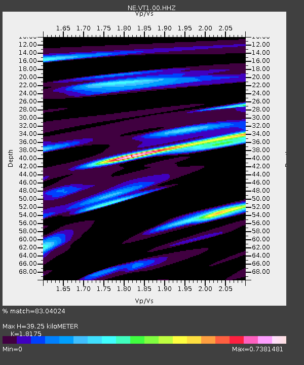
| Estimated Moho Depth: |
39.25 km |
| Estimated Crust Vp/Vs: |
1.82 |
| Assumed Crust Vp: |
6.419 km/s |
| Estimated Crust Vs: |
3.532 km/s |
| Estimated Crust Poisson's Ratio: |
0.28 |
|
| Radial Match: |
83.04024 % |
| Radial Bump: |
400 |
| Transverse Match: |
64.49443 % |
| Transverse Bump: |
400 |
| SOD ConfigId: |
1464191 |
| Insert Time: |
2016-04-03 23:15:30.506 +0000 |
| GWidth: |
2.5 |
| Max Bumps: |
400 |
| Tol: |
0.001 |
|

Signal To Noise
| Channel | StoN | STA | LTA |
| NE:VT1:00:HHZ:20160320T23:01:04.003997Z | 3.8315449 | 8.890179E-7 | 2.3202597E-7 |
| NE:VT1:00:HH1:20160320T23:01:04.003997Z | 2.6198995 | 5.5641016E-7 | 2.1237842E-7 |
| NE:VT1:00:HH2:20160320T23:01:04.003997Z | 1.7689106 | 4.5252577E-7 | 2.5582173E-7 |
| Arrivals |
| Ps | 5.2 SECOND |
| PpPs | 17 SECOND |
| PsPs/PpSs | 22 SECOND |


