You are here: Home > Network List > TA - USArray Transportable Network (new EarthScope stations) Stations List
> Station T25A Trinidad, CO, USA > Earthquake Result Viewer
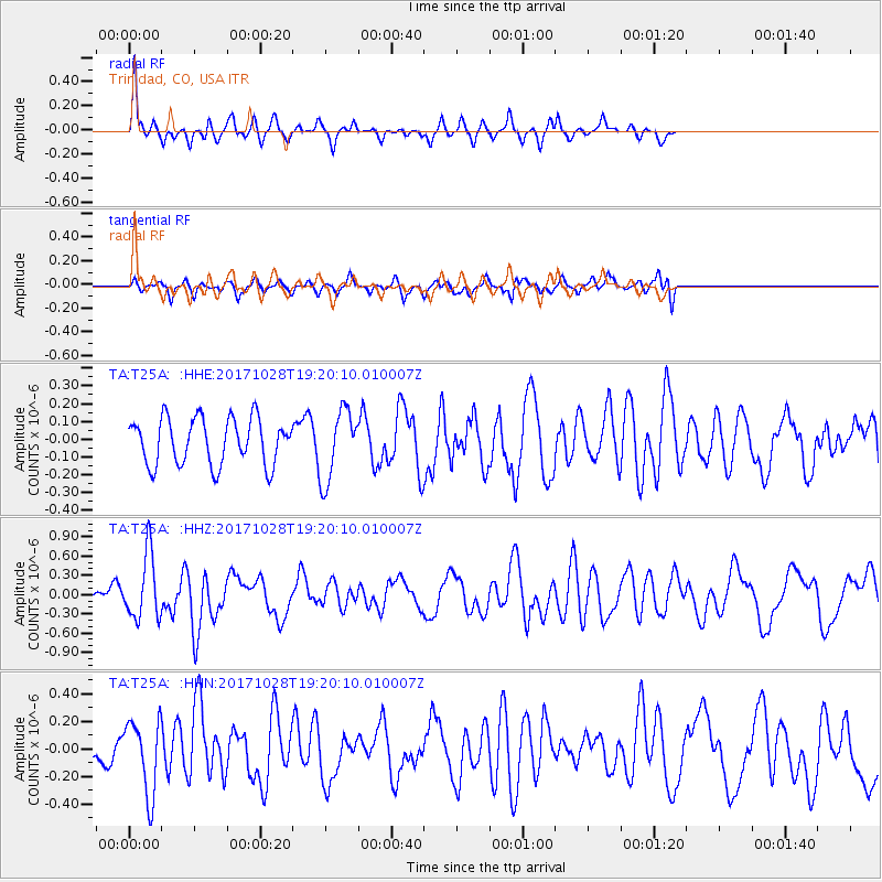
T25A Trinidad, CO, USA - Earthquake Result Viewer
*The percent match for this event was below the threshold and hence no stack was calculated.
| Earthquake location: |
North Of Franz Josef Land |
| Earthquake latitude/longitude: |
86.9/55.1 |
| Earthquake time(UTC): |
2017/10/28 (301) 19:11:01 GMT |
| Earthquake Depth: |
10 km |
| Earthquake Magnitude: |
6.0 Mww |
| Earthquake Catalog/Contributor: |
NEIC PDE/us |
|
| Network: |
TA USArray Transportable Network (new EarthScope stations) |
| Station: |
T25A Trinidad, CO, USA |
| Lat/Lon: |
37.14 N/104.41 W |
| Elevation: |
2017 m |
|
| Distance: |
56.0 deg |
| Az: |
340.311 deg |
| Baz: |
1.318 deg |
| Ray Param: |
$rayparam |
*The percent match for this event was below the threshold and hence was not used in the summary stack. |
|
| Radial Match: |
76.515915 % |
| Radial Bump: |
400 |
| Transverse Match: |
50.67775 % |
| Transverse Bump: |
376 |
| SOD ConfigId: |
13570011 |
| Insert Time: |
2019-04-29 01:03:07.258 +0000 |
| GWidth: |
2.5 |
| Max Bumps: |
400 |
| Tol: |
0.001 |
|
Signal To Noise
| Channel | StoN | STA | LTA |
| TA:T25A: :HHZ:20171028T19:20:10.010007Z | 5.3052187 | 5.0436705E-7 | 9.506998E-8 |
| TA:T25A: :HHN:20171028T19:20:10.010007Z | 2.7249866 | 2.667937E-7 | 9.790642E-8 |
| TA:T25A: :HHE:20171028T19:20:10.010007Z | 1.5086901 | 1.9851637E-7 | 1.3158194E-7 |
| Arrivals |
| Ps | |
| PpPs | |
| PsPs/PpSs | |


