You are here: Home > Network List > TA - USArray Transportable Network (new EarthScope stations) Stations List
> Station T18A Mexican Hat, UT, USA > Earthquake Result Viewer
T18A Mexican Hat, UT, USA - Earthquake Result Viewer
| Earthquake location: |
Andreanof Islands, Aleutian Is. |
| Earthquake latitude/longitude: |
51.4/-179.0 |
| Earthquake time(UTC): |
2007/12/21 (355) 07:24:34 GMT |
| Earthquake Depth: |
30 km |
| Earthquake Magnitude: |
6.1 MB, 6.2 MW, 6.3 ML |
| Earthquake Catalog/Contributor: |
WHDF/NEIC |
|
| Network: |
TA USArray Transportable Network (new EarthScope stations) |
| Station: |
T18A Mexican Hat, UT, USA |
| Lat/Lon: |
37.14 N/109.87 W |
| Elevation: |
1297 m |
|
| Distance: |
49.7 deg |
| Az: |
78.283 deg |
| Baz: |
309.804 deg |
| Ray Param: |
0.0684918 |
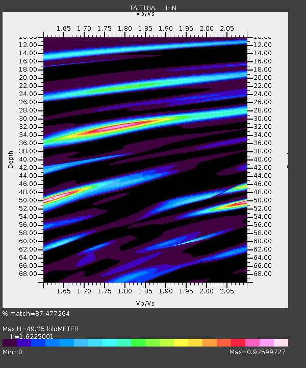
| Estimated Moho Depth: |
49.25 km |
| Estimated Crust Vp/Vs: |
1.62 |
| Assumed Crust Vp: |
6.476 km/s |
| Estimated Crust Vs: |
3.991 km/s |
| Estimated Crust Poisson's Ratio: |
0.19 |
|
| Radial Match: |
87.477264 % |
| Radial Bump: |
400 |
| Transverse Match: |
71.08153 % |
| Transverse Bump: |
400 |
| SOD ConfigId: |
2564 |
| Insert Time: |
2010-03-06 05:33:49.350 +0000 |
| GWidth: |
2.5 |
| Max Bumps: |
400 |
| Tol: |
0.001 |
|

Signal To Noise
| Channel | StoN | STA | LTA |
| TA:T18A: :BHN:20071221T07:32:53.12501Z | 3.171052 | 4.4880503E-7 | 1.4153191E-7 |
| TA:T18A: :BHE:20071221T07:32:53.12501Z | 1.8436685 | 3.1686034E-7 | 1.7186406E-7 |
| TA:T18A: :BHZ:20071221T07:32:53.12501Z | 6.477176 | 9.977846E-7 | 1.5404622E-7 |
| Arrivals |
| Ps | 5.1 SECOND |
| PpPs | 19 SECOND |
| PsPs/PpSs | 24 SECOND |


