You are here: Home > Network List > TA - USArray Transportable Network (new EarthScope stations) Stations List
> Station T18A Mexican Hat, UT, USA > Earthquake Result Viewer
T18A Mexican Hat, UT, USA - Earthquake Result Viewer

| Earthquake location: |
South Of Fiji Islands |
| Earthquake latitude/longitude: |
-25.8/179.5 |
| Earthquake time(UTC): |
2007/10/16 (289) 21:05:43 GMT |
| Earthquake Depth: |
509 km |
| Earthquake Magnitude: |
6.2 MB, 6.6 MW, 6.5 MW |
| Earthquake Catalog/Contributor: |
WHDF/NEIC |
|
| Network: |
TA USArray Transportable Network (new EarthScope stations) |
| Station: |
T18A Mexican Hat, UT, USA |
| Lat/Lon: |
37.14 N/109.87 W |
| Elevation: |
1297 m |
|
| Distance: |
91.2 deg |
| Az: |
48.931 deg |
| Baz: |
238.278 deg |
| Ray Param: |
0.041338492 |
| Estimated Moho Depth: |
44.75 km |
| Estimated Crust Vp/Vs: |
1.76 |
| Assumed Crust Vp: |
6.476 km/s |
| Estimated Crust Vs: |
3.685 km/s |
| Estimated Crust Poisson's Ratio: |
0.26 |
|
| Radial Match: |
87.97075 % |
| Radial Bump: |
273 |
| Transverse Match: |
81.06705 % |
| Transverse Bump: |
385 |
| SOD ConfigId: |
2564 |
| Insert Time: |
2010-03-06 05:33:59.695 +0000 |
| GWidth: |
2.5 |
| Max Bumps: |
400 |
| Tol: |
0.001 |
|
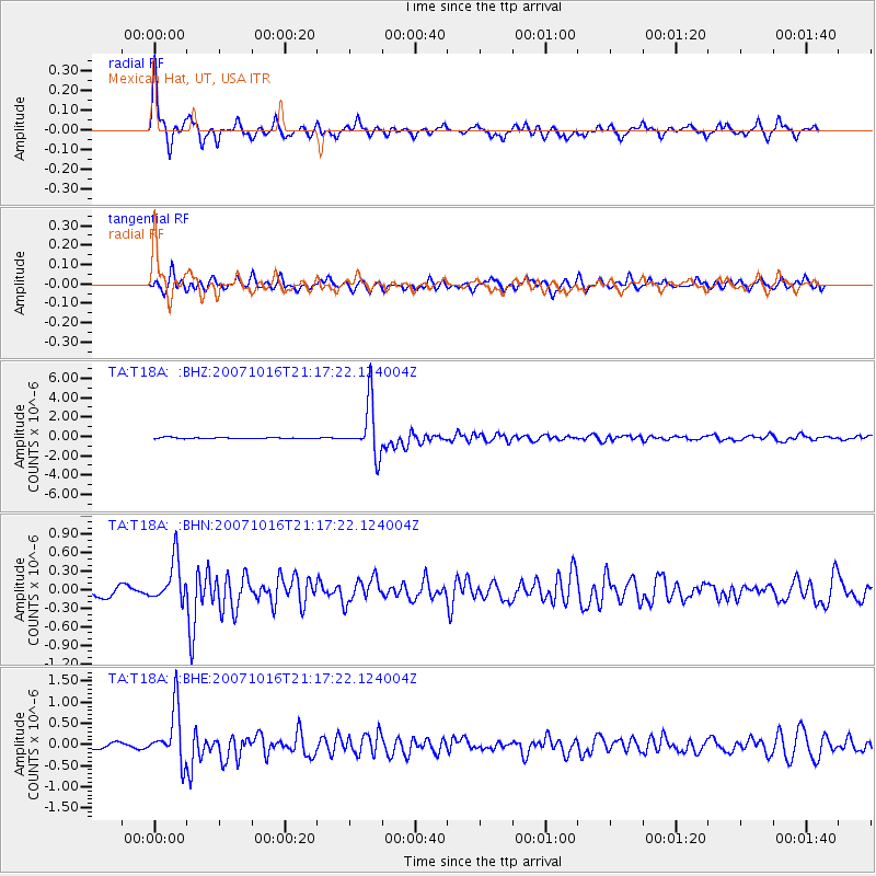
Signal To Noise
| Channel | StoN | STA | LTA |
| TA:T18A: :BHN:20071016T21:17:22.124004Z | 5.562072 | 3.43756E-7 | 6.180359E-8 |
| TA:T18A: :BHE:20071016T21:17:22.124004Z | 12.871129 | 6.371475E-7 | 4.9502066E-8 |
| TA:T18A: :BHZ:20071016T21:17:22.124004Z | 45.447525 | 2.7129026E-6 | 5.969308E-8 |
| Arrivals |
| Ps | 5.3 SECOND |
| PpPs | 19 SECOND |
| PsPs/PpSs | 24 SECOND |


