You are here: Home > Network List > TA - USArray Transportable Network (new EarthScope stations) Stations List
> Station T18A Mexican Hat, UT, USA > Earthquake Result Viewer
T18A Mexican Hat, UT, USA - Earthquake Result Viewer
| Earthquake location: |
Southeast Of Loyalty Islands |
| Earthquake latitude/longitude: |
-21.1/169.3 |
| Earthquake time(UTC): |
2007/09/27 (270) 19:57:44 GMT |
| Earthquake Depth: |
9.0 km |
| Earthquake Magnitude: |
6.2 MB, 6.3 MS, 6.1 MW, 6.1 MW |
| Earthquake Catalog/Contributor: |
WHDF/NEIC |
|
| Network: |
TA USArray Transportable Network (new EarthScope stations) |
| Station: |
T18A Mexican Hat, UT, USA |
| Lat/Lon: |
37.14 N/109.87 W |
| Elevation: |
1297 m |
|
| Distance: |
95.5 deg |
| Az: |
52.434 deg |
| Baz: |
247.844 deg |
| Ray Param: |
0.040757637 |
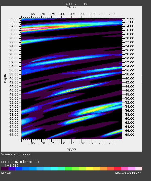
| Estimated Moho Depth: |
15.25 km |
| Estimated Crust Vp/Vs: |
1.62 |
| Assumed Crust Vp: |
6.476 km/s |
| Estimated Crust Vs: |
4.01 km/s |
| Estimated Crust Poisson's Ratio: |
0.19 |
|
| Radial Match: |
81.79723 % |
| Radial Bump: |
400 |
| Transverse Match: |
60.40071 % |
| Transverse Bump: |
400 |
| SOD ConfigId: |
2564 |
| Insert Time: |
2010-03-06 05:34:05.477 +0000 |
| GWidth: |
2.5 |
| Max Bumps: |
400 |
| Tol: |
0.001 |
|
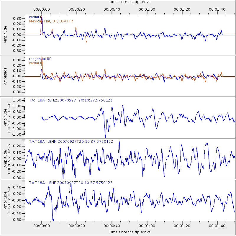
Signal To Noise
| Channel | StoN | STA | LTA |
| TA:T18A: :BHN:20070927T20:10:37.575012Z | 1.0099182 | 7.2851236E-8 | 7.213578E-8 |
| TA:T18A: :BHE:20070927T20:10:37.575012Z | 1.9641004 | 1.7755471E-7 | 9.0400015E-8 |
| TA:T18A: :BHZ:20070927T20:10:37.575012Z | 3.589348 | 3.819648E-7 | 1.0641621E-7 |
| Arrivals |
| Ps | 1.5 SECOND |
| PpPs | 6.0 SECOND |
| PsPs/PpSs | 7.5 SECOND |


