You are here: Home > Network List > UW - Pacific Northwest Regional Seismic Network Stations List
> Station WOLL Wollman Farm, Schrag, WA, USA > Earthquake Result Viewer
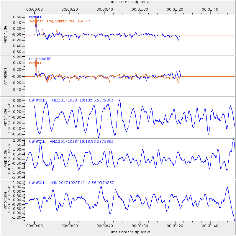
WOLL Wollman Farm, Schrag, WA, USA - Earthquake Result Viewer
*The percent match for this event was below the threshold and hence no stack was calculated.
| Earthquake location: |
North Of Franz Josef Land |
| Earthquake latitude/longitude: |
86.9/55.1 |
| Earthquake time(UTC): |
2017/10/28 (301) 19:11:01 GMT |
| Earthquake Depth: |
10 km |
| Earthquake Magnitude: |
6.0 Mww |
| Earthquake Catalog/Contributor: |
NEIC PDE/us |
|
| Network: |
UW Pacific Northwest Regional Seismic Network |
| Station: |
WOLL Wollman Farm, Schrag, WA, USA |
| Lat/Lon: |
47.06 N/118.92 W |
| Elevation: |
385 m |
|
| Distance: |
46.2 deg |
| Az: |
354.375 deg |
| Baz: |
0.448 deg |
| Ray Param: |
$rayparam |
*The percent match for this event was below the threshold and hence was not used in the summary stack. |
|
| Radial Match: |
67.087906 % |
| Radial Bump: |
400 |
| Transverse Match: |
48.75549 % |
| Transverse Bump: |
400 |
| SOD ConfigId: |
13570011 |
| Insert Time: |
2019-04-29 01:04:23.444 +0000 |
| GWidth: |
2.5 |
| Max Bumps: |
400 |
| Tol: |
0.001 |
|
Signal To Noise
| Channel | StoN | STA | LTA |
| UW:WOLL: :HHZ:20171028T19:18:56.937986Z | 1.546676 | 9.199127E-7 | 5.947675E-7 |
| UW:WOLL: :HHN:20171028T19:18:56.937986Z | 1.2929205 | 3.156039E-7 | 2.4410156E-7 |
| UW:WOLL: :HHE:20171028T19:18:56.937986Z | 1.1827749 | 3.3451042E-7 | 2.8281835E-7 |
| Arrivals |
| Ps | |
| PpPs | |
| PsPs/PpSs | |


