You are here: Home > Network List > TA - USArray Transportable Network (new EarthScope stations) Stations List
> Station T18A Mexican Hat, UT, USA > Earthquake Result Viewer
T18A Mexican Hat, UT, USA - Earthquake Result Viewer

| Earthquake location: |
Iceland |
| Earthquake latitude/longitude: |
64.0/-21.0 |
| Earthquake time(UTC): |
2008/05/29 (150) 15:46:00 GMT |
| Earthquake Depth: |
10 km |
| Earthquake Magnitude: |
6.0 MB, 6.2 MS, 6.3 MW, 6.2 MW |
| Earthquake Catalog/Contributor: |
WHDF/NEIC |
|
| Network: |
TA USArray Transportable Network (new EarthScope stations) |
| Station: |
T18A Mexican Hat, UT, USA |
| Lat/Lon: |
37.14 N/109.87 W |
| Elevation: |
1297 m |
|
| Distance: |
56.9 deg |
| Az: |
287.418 deg |
| Baz: |
31.747 deg |
| Ray Param: |
0.06386194 |
| Estimated Moho Depth: |
69.5 km |
| Estimated Crust Vp/Vs: |
1.61 |
| Assumed Crust Vp: |
6.476 km/s |
| Estimated Crust Vs: |
4.016 km/s |
| Estimated Crust Poisson's Ratio: |
0.19 |
|
| Radial Match: |
90.12303 % |
| Radial Bump: |
298 |
| Transverse Match: |
78.41936 % |
| Transverse Bump: |
398 |
| SOD ConfigId: |
2504 |
| Insert Time: |
2010-03-06 05:34:59.411 +0000 |
| GWidth: |
2.5 |
| Max Bumps: |
400 |
| Tol: |
0.001 |
|
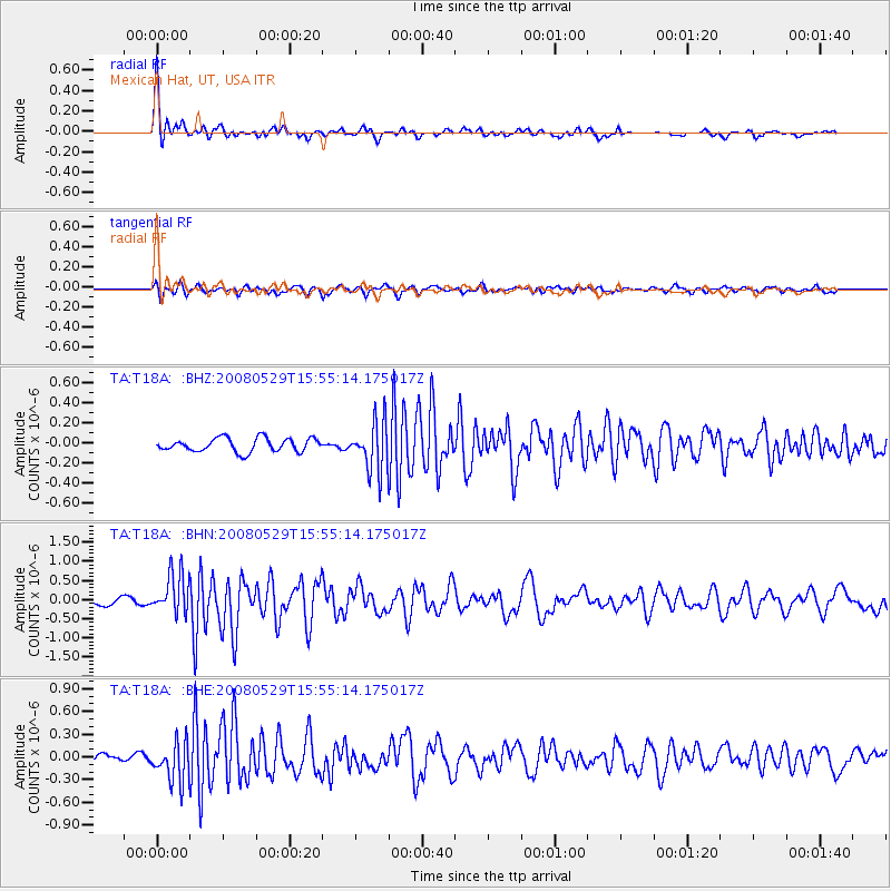
Signal To Noise
| Channel | StoN | STA | LTA |
| TA:T18A: :BHN:20080529T15:55:14.175017Z | 7.245046 | 5.26926E-7 | 7.272914E-8 |
| TA:T18A: :BHE:20080529T15:55:14.175017Z | 5.732625 | 2.5995053E-7 | 4.534581E-8 |
| TA:T18A: :BHZ:20080529T15:55:14.175017Z | 3.6818612 | 2.4790833E-7 | 6.7332344E-8 |
| Arrivals |
| Ps | 7.0 SECOND |
| PpPs | 26 SECOND |
| PsPs/PpSs | 33 SECOND |


