You are here: Home > Network List > TA - USArray Transportable Network (new EarthScope stations) Stations List
> Station T18A Mexican Hat, UT, USA > Earthquake Result Viewer
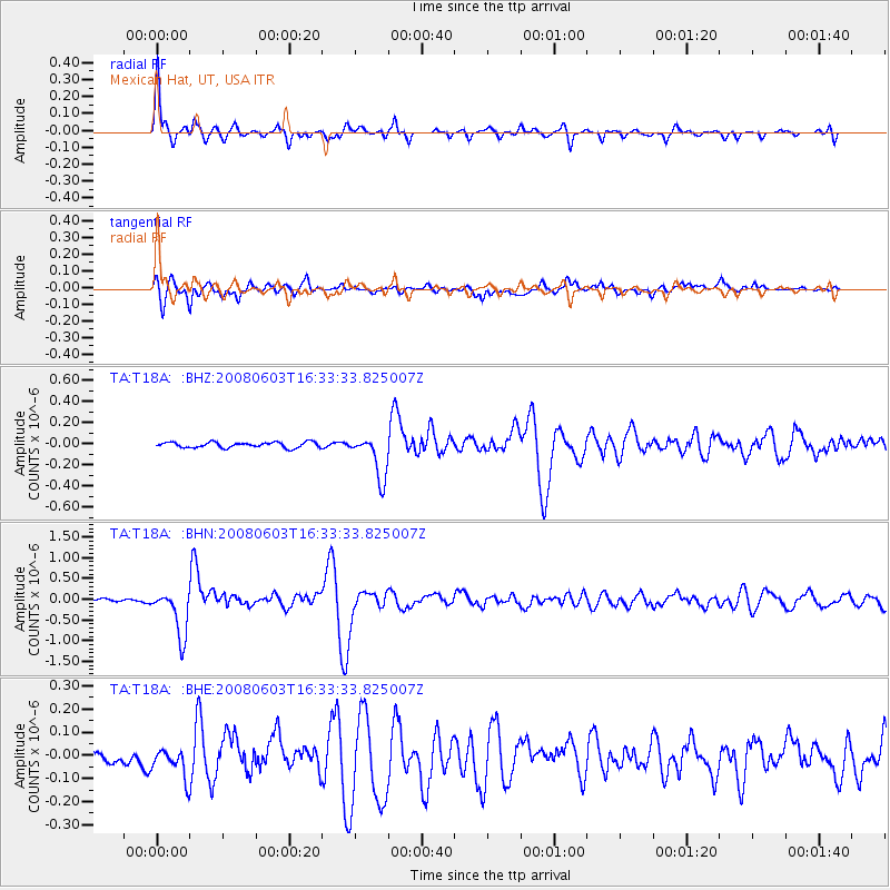
T18A Mexican Hat, UT, USA - Earthquake Result Viewer

| Earthquake location: |
Solomon Islands |
| Earthquake latitude/longitude: |
-10.5/161.3 |
| Earthquake time(UTC): |
2008/06/03 (155) 16:20:50 GMT |
| Earthquake Depth: |
84 km |
| Earthquake Magnitude: |
6.2 MB, 6.2 MW, 6.2 MW |
| Earthquake Catalog/Contributor: |
WHDF/NEIC |
|
| Network: |
TA USArray Transportable Network (new EarthScope stations) |
| Station: |
T18A Mexican Hat, UT, USA |
| Lat/Lon: |
37.14 N/109.87 W |
| Elevation: |
1297 m |
|
| Distance: |
95.3 deg |
| Az: |
53.367 deg |
| Baz: |
260.948 deg |
| Ray Param: |
0.040749162 |
| Estimated Moho Depth: |
15.5 km |
| Estimated Crust Vp/Vs: |
1.60 |
| Assumed Crust Vp: |
6.476 km/s |
| Estimated Crust Vs: |
4.041 km/s |
| Estimated Crust Poisson's Ratio: |
0.18 |
|
| Radial Match: |
93.9503 % |
| Radial Bump: |
388 |
| Transverse Match: |
85.887505 % |
| Transverse Bump: |
400 |
| SOD ConfigId: |
2504 |
| Insert Time: |
2010-03-06 05:35:06.139 +0000 |
| GWidth: |
2.5 |
| Max Bumps: |
400 |
| Tol: |
0.001 |
|
Signal To Noise
| Channel | StoN | STA | LTA |
| TA:T18A: :BHN:20080603T16:33:33.825007Z | 14.704745 | 5.6151686E-7 | 3.8186098E-8 |
| TA:T18A: :BHE:20080603T16:33:33.825007Z | 2.7278981 | 6.5251044E-8 | 2.3919897E-8 |
| TA:T18A: :BHZ:20080603T16:33:33.825007Z | 7.8538623 | 2.0444679E-7 | 2.6031369E-8 |
| Arrivals |
| Ps | 1.5 SECOND |
| PpPs | 6.1 SECOND |
| PsPs/PpSs | 7.6 SECOND |


