You are here: Home > Network List > US - United States National Seismic Network Stations List
> Station BW06 Boulder Array Site 6 (Pinedale), Wyoming, USA > Earthquake Result Viewer
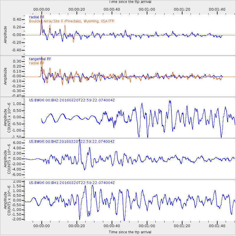
BW06 Boulder Array Site 6 (Pinedale), Wyoming, USA - Earthquake Result Viewer
| Earthquake location: |
Near East Coast Of Kamchatka |
| Earthquake latitude/longitude: |
54.3/162.8 |
| Earthquake time(UTC): |
2016/03/20 (080) 22:50:20 GMT |
| Earthquake Depth: |
31 km |
| Earthquake Magnitude: |
6.4 MWC, 6.2 MWB, 6.6 MI |
| Earthquake Catalog/Contributor: |
NEIC PDE/NEIC COMCAT |
|
| Network: |
US United States National Seismic Network |
| Station: |
BW06 Boulder Array Site 6 (Pinedale), Wyoming, USA |
| Lat/Lon: |
42.77 N/109.56 W |
| Elevation: |
2224 m |
|
| Distance: |
55.5 deg |
| Az: |
63.199 deg |
| Baz: |
314.775 deg |
| Ray Param: |
0.064685084 |
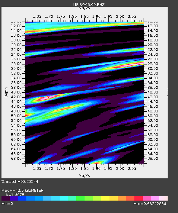
| Estimated Moho Depth: |
42.0 km |
| Estimated Crust Vp/Vs: |
1.70 |
| Assumed Crust Vp: |
6.161 km/s |
| Estimated Crust Vs: |
3.629 km/s |
| Estimated Crust Poisson's Ratio: |
0.23 |
|
| Radial Match: |
93.23544 % |
| Radial Bump: |
392 |
| Transverse Match: |
91.71189 % |
| Transverse Bump: |
343 |
| SOD ConfigId: |
1464191 |
| Insert Time: |
2016-04-03 23:18:01.102 +0000 |
| GWidth: |
2.5 |
| Max Bumps: |
400 |
| Tol: |
0.001 |
|
Signal To Noise
| Channel | StoN | STA | LTA |
| US:BW06:00:BHZ:20160320T22:59:22.074004Z | 2.9977102 | 6.87958E-7 | 2.2949449E-7 |
| US:BW06:00:BH1:20160320T22:59:22.074004Z | 4.667156 | 2.967483E-7 | 6.358225E-8 |
| US:BW06:00:BH2:20160320T22:59:22.074004Z | 1.2763506 | 2.3872923E-7 | 1.8704048E-7 |
| Arrivals |
| Ps | 5.0 SECOND |
| PpPs | 18 SECOND |
| PsPs/PpSs | 22 SECOND |


