You are here: Home > Network List > TA - USArray Transportable Network (new EarthScope stations) Stations List
> Station 121A Cookes Peak, Deming, NM, USA > Earthquake Result Viewer
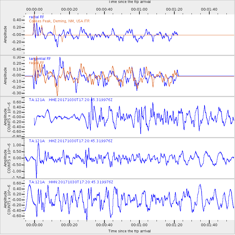
121A Cookes Peak, Deming, NM, USA - Earthquake Result Viewer
*The percent match for this event was below the threshold and hence no stack was calculated.
| Earthquake location: |
Central Peru |
| Earthquake latitude/longitude: |
-10.7/-74.7 |
| Earthquake time(UTC): |
2017/10/30 (303) 17:12:06 GMT |
| Earthquake Depth: |
101 km |
| Earthquake Magnitude: |
5.7 mb |
| Earthquake Catalog/Contributor: |
NEIC PDE/us |
|
| Network: |
TA USArray Transportable Network (new EarthScope stations) |
| Station: |
121A Cookes Peak, Deming, NM, USA |
| Lat/Lon: |
32.53 N/107.79 W |
| Elevation: |
1652 m |
|
| Distance: |
53.4 deg |
| Az: |
324.929 deg |
| Baz: |
138.052 deg |
| Ray Param: |
$rayparam |
*The percent match for this event was below the threshold and hence was not used in the summary stack. |
|
| Radial Match: |
59.693623 % |
| Radial Bump: |
400 |
| Transverse Match: |
52.97388 % |
| Transverse Bump: |
400 |
| SOD ConfigId: |
13570011 |
| Insert Time: |
2019-04-29 01:11:05.726 +0000 |
| GWidth: |
2.5 |
| Max Bumps: |
400 |
| Tol: |
0.001 |
|
Signal To Noise
| Channel | StoN | STA | LTA |
| TA:121A: :HHZ:20171030T17:20:45.319976Z | 3.5655053 | 5.7589966E-7 | 1.6151978E-7 |
| TA:121A: :HHN:20171030T17:20:45.319976Z | 1.4982089 | 2.5318167E-7 | 1.6898956E-7 |
| TA:121A: :HHE:20171030T17:20:45.319976Z | 3.2014263 | 3.498271E-7 | 1.09272264E-7 |
| Arrivals |
| Ps | |
| PpPs | |
| PsPs/PpSs | |


