You are here: Home > Network List > US - United States National Seismic Network Stations List
> Station MSO Missoula, Montana, USA > Earthquake Result Viewer
MSO Missoula, Montana, USA - Earthquake Result Viewer

| Earthquake location: |
Near East Coast Of Kamchatka |
| Earthquake latitude/longitude: |
54.3/162.8 |
| Earthquake time(UTC): |
2016/03/20 (080) 22:50:20 GMT |
| Earthquake Depth: |
31 km |
| Earthquake Magnitude: |
6.4 MWC, 6.2 MWB, 6.6 MI |
| Earthquake Catalog/Contributor: |
NEIC PDE/NEIC COMCAT |
|
| Network: |
US United States National Seismic Network |
| Station: |
MSO Missoula, Montana, USA |
| Lat/Lon: |
46.83 N/113.94 W |
| Elevation: |
1264 m |
|
| Distance: |
50.5 deg |
| Az: |
62.136 deg |
| Baz: |
311.055 deg |
| Ray Param: |
0.06797544 |
| Estimated Moho Depth: |
45.0 km |
| Estimated Crust Vp/Vs: |
1.63 |
| Assumed Crust Vp: |
6.353 km/s |
| Estimated Crust Vs: |
3.892 km/s |
| Estimated Crust Poisson's Ratio: |
0.20 |
|
| Radial Match: |
92.05115 % |
| Radial Bump: |
400 |
| Transverse Match: |
80.65742 % |
| Transverse Bump: |
400 |
| SOD ConfigId: |
1464191 |
| Insert Time: |
2016-04-03 23:19:48.291 +0000 |
| GWidth: |
2.5 |
| Max Bumps: |
400 |
| Tol: |
0.001 |
|
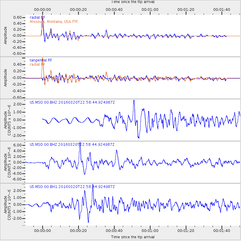
Signal To Noise
| Channel | StoN | STA | LTA |
| US:MSO:00:BHZ:20160320T22:58:44.924987Z | 5.6098123 | 9.461708E-7 | 1.6866355E-7 |
| US:MSO:00:BH1:20160320T22:58:44.924987Z | 1.4659089 | 3.1902104E-7 | 2.1762678E-7 |
| US:MSO:00:BH2:20160320T22:58:44.924987Z | 1.9085038 | 4.0994976E-7 | 2.1480164E-7 |
| Arrivals |
| Ps | 4.8 SECOND |
| PpPs | 18 SECOND |
| PsPs/PpSs | 22 SECOND |


