You are here: Home > Network List > TA - USArray Transportable Network (new EarthScope stations) Stations List
> Station T18A Mexican Hat, UT, USA > Earthquake Result Viewer
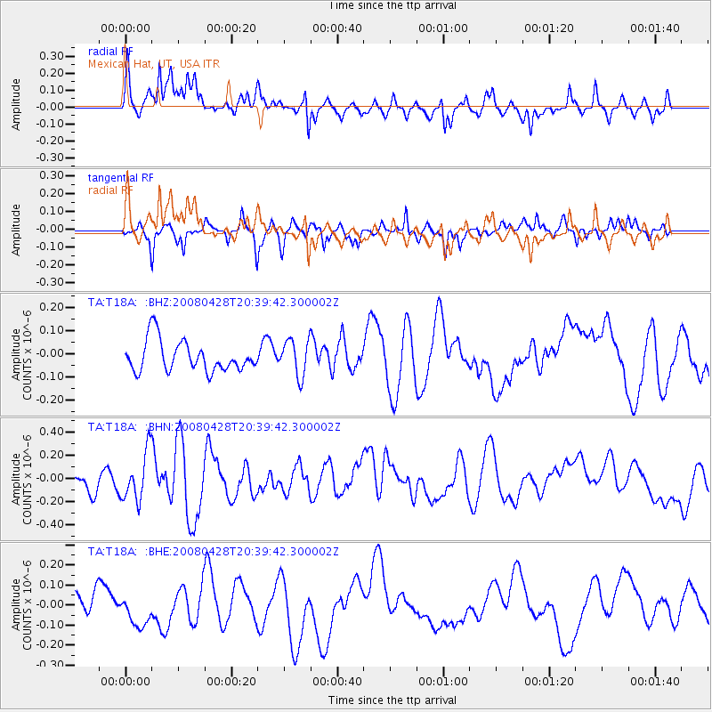
T18A Mexican Hat, UT, USA - Earthquake Result Viewer
*The percent match for this event was below the threshold and hence no stack was calculated.
| Earthquake location: |
Loyalty Islands |
| Earthquake latitude/longitude: |
-20.2/168.8 |
| Earthquake time(UTC): |
2008/04/28 (119) 20:26:53 GMT |
| Earthquake Depth: |
35 km |
| Earthquake Magnitude: |
5.8 MB, 5.7 MS, 6.1 MW, 6.0 MW |
| Earthquake Catalog/Contributor: |
WHDF/NEIC |
|
| Network: |
TA USArray Transportable Network (new EarthScope stations) |
| Station: |
T18A Mexican Hat, UT, USA |
| Lat/Lon: |
37.14 N/109.87 W |
| Elevation: |
1297 m |
|
| Distance: |
95.3 deg |
| Az: |
52.505 deg |
| Baz: |
248.792 deg |
| Ray Param: |
$rayparam |
*The percent match for this event was below the threshold and hence was not used in the summary stack. |
|
| Radial Match: |
69.51136 % |
| Radial Bump: |
400 |
| Transverse Match: |
54.474133 % |
| Transverse Bump: |
298 |
| SOD ConfigId: |
2504 |
| Insert Time: |
2010-03-06 05:36:37.873 +0000 |
| GWidth: |
2.5 |
| Max Bumps: |
400 |
| Tol: |
0.001 |
|
Signal To Noise
| Channel | StoN | STA | LTA |
| TA:T18A: :BHN:20080428T20:39:42.300002Z | 2.6121144 | 2.0976934E-7 | 8.0306336E-8 |
| TA:T18A: :BHE:20080428T20:39:42.300002Z | 1.1270355 | 8.168512E-8 | 7.247786E-8 |
| TA:T18A: :BHZ:20080428T20:39:42.300002Z | 1.1854235 | 7.823999E-8 | 6.600172E-8 |
| Arrivals |
| Ps | |
| PpPs | |
| PsPs/PpSs | |


