You are here: Home > Network List > US - United States National Seismic Network Stations List
> Station TZTN Tazewell, Tennessee, USA > Earthquake Result Viewer
TZTN Tazewell, Tennessee, USA - Earthquake Result Viewer
| Earthquake location: |
Near East Coast Of Kamchatka |
| Earthquake latitude/longitude: |
54.3/162.8 |
| Earthquake time(UTC): |
2016/03/20 (080) 22:50:20 GMT |
| Earthquake Depth: |
31 km |
| Earthquake Magnitude: |
6.4 MWC, 6.2 MWB, 6.6 MI |
| Earthquake Catalog/Contributor: |
NEIC PDE/NEIC COMCAT |
|
| Network: |
US United States National Seismic Network |
| Station: |
TZTN Tazewell, Tennessee, USA |
| Lat/Lon: |
36.54 N/83.55 W |
| Elevation: |
394 m |
|
| Distance: |
73.1 deg |
| Az: |
50.454 deg |
| Baz: |
325.889 deg |
| Ray Param: |
0.053206734 |
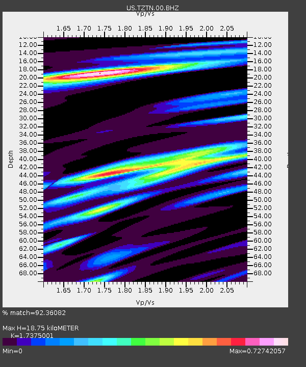
| Estimated Moho Depth: |
18.75 km |
| Estimated Crust Vp/Vs: |
1.74 |
| Assumed Crust Vp: |
6.476 km/s |
| Estimated Crust Vs: |
3.727 km/s |
| Estimated Crust Poisson's Ratio: |
0.25 |
|
| Radial Match: |
92.36082 % |
| Radial Bump: |
400 |
| Transverse Match: |
80.95792 % |
| Transverse Bump: |
400 |
| SOD ConfigId: |
1464191 |
| Insert Time: |
2016-04-03 23:20:20.516 +0000 |
| GWidth: |
2.5 |
| Max Bumps: |
400 |
| Tol: |
0.001 |
|

Signal To Noise
| Channel | StoN | STA | LTA |
| US:TZTN:00:BHZ:20160320T23:01:16.699004Z | 2.8234127 | 7.6561344E-7 | 2.71166E-7 |
| US:TZTN:00:BH1:20160320T23:01:16.699004Z | 0.84584147 | 1.3991422E-7 | 1.6541424E-7 |
| US:TZTN:00:BH2:20160320T23:01:16.699004Z | 1.8226794 | 2.0459066E-7 | 1.122472E-7 |
| Arrivals |
| Ps | 2.2 SECOND |
| PpPs | 7.6 SECOND |
| PsPs/PpSs | 9.9 SECOND |


