You are here: Home > Network List > CI - Caltech Regional Seismic Network Stations List
> Station FMP Fort MacArthur Park, Pt. Fermin San Pedro, CA, USA > Earthquake Result Viewer
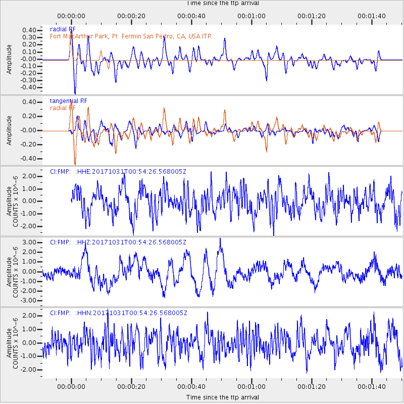
FMP Fort MacArthur Park, Pt. Fermin San Pedro, CA, USA - Earthquake Result Viewer
*The percent match for this event was below the threshold and hence no stack was calculated.
| Earthquake location: |
Southeast Of Loyalty Islands |
| Earthquake latitude/longitude: |
-21.7/169.2 |
| Earthquake time(UTC): |
2017/10/31 (304) 00:42:06 GMT |
| Earthquake Depth: |
9.1 km |
| Earthquake Magnitude: |
6.8 Mww |
| Earthquake Catalog/Contributor: |
NEIC PDE/us |
|
| Network: |
CI Caltech Regional Seismic Network |
| Station: |
FMP Fort MacArthur Park, Pt. Fermin San Pedro, CA, USA |
| Lat/Lon: |
33.71 N/118.29 W |
| Elevation: |
89 m |
|
| Distance: |
88.3 deg |
| Az: |
52.686 deg |
| Baz: |
242.567 deg |
| Ray Param: |
$rayparam |
*The percent match for this event was below the threshold and hence was not used in the summary stack. |
|
| Radial Match: |
65.84487 % |
| Radial Bump: |
400 |
| Transverse Match: |
75.6114 % |
| Transverse Bump: |
400 |
| SOD ConfigId: |
13570011 |
| Insert Time: |
2019-04-29 01:17:47.040 +0000 |
| GWidth: |
2.5 |
| Max Bumps: |
400 |
| Tol: |
0.001 |
|
Signal To Noise
| Channel | StoN | STA | LTA |
| CI:FMP: :HHZ:20171031T00:54:26.568005Z | 2.7831352 | 1.1043553E-6 | 3.968026E-7 |
| CI:FMP: :HHN:20171031T00:54:26.568005Z | 1.0797584 | 6.5454776E-7 | 6.0619834E-7 |
| CI:FMP: :HHE:20171031T00:54:26.568005Z | 0.7293353 | 7.385447E-7 | 1.0126272E-6 |
| Arrivals |
| Ps | |
| PpPs | |
| PsPs/PpSs | |


