You are here: Home > Network List > CI - Caltech Regional Seismic Network Stations List
> Station MPP McPhearson Peak > Earthquake Result Viewer
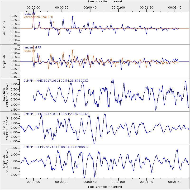
MPP McPhearson Peak - Earthquake Result Viewer
*The percent match for this event was below the threshold and hence no stack was calculated.
| Earthquake location: |
Southeast Of Loyalty Islands |
| Earthquake latitude/longitude: |
-21.7/169.2 |
| Earthquake time(UTC): |
2017/10/31 (304) 00:42:06 GMT |
| Earthquake Depth: |
9.1 km |
| Earthquake Magnitude: |
6.8 Mww |
| Earthquake Catalog/Contributor: |
NEIC PDE/us |
|
| Network: |
CI Caltech Regional Seismic Network |
| Station: |
MPP McPhearson Peak |
| Lat/Lon: |
34.89 N/119.81 W |
| Elevation: |
1739 m |
|
| Distance: |
87.7 deg |
| Az: |
51.06 deg |
| Baz: |
241.657 deg |
| Ray Param: |
$rayparam |
*The percent match for this event was below the threshold and hence was not used in the summary stack. |
|
| Radial Match: |
78.50395 % |
| Radial Bump: |
298 |
| Transverse Match: |
60.157135 % |
| Transverse Bump: |
388 |
| SOD ConfigId: |
13570011 |
| Insert Time: |
2019-04-29 01:17:56.676 +0000 |
| GWidth: |
2.5 |
| Max Bumps: |
400 |
| Tol: |
0.001 |
|
Signal To Noise
| Channel | StoN | STA | LTA |
| CI:MPP: :HHZ:20171031T00:54:23.878003Z | 2.2179065 | 6.320288E-7 | 2.8496638E-7 |
| CI:MPP: :HHN:20171031T00:54:23.878003Z | 0.51617694 | 1.948514E-7 | 3.7748953E-7 |
| CI:MPP: :HHE:20171031T00:54:23.878003Z | 1.8527383 | 7.5212694E-7 | 4.059542E-7 |
| Arrivals |
| Ps | |
| PpPs | |
| PsPs/PpSs | |


