You are here: Home > Network List > CI - Caltech Regional Seismic Network Stations List
> Station MPM Manuel Prospect Mine, California, USA > Earthquake Result Viewer
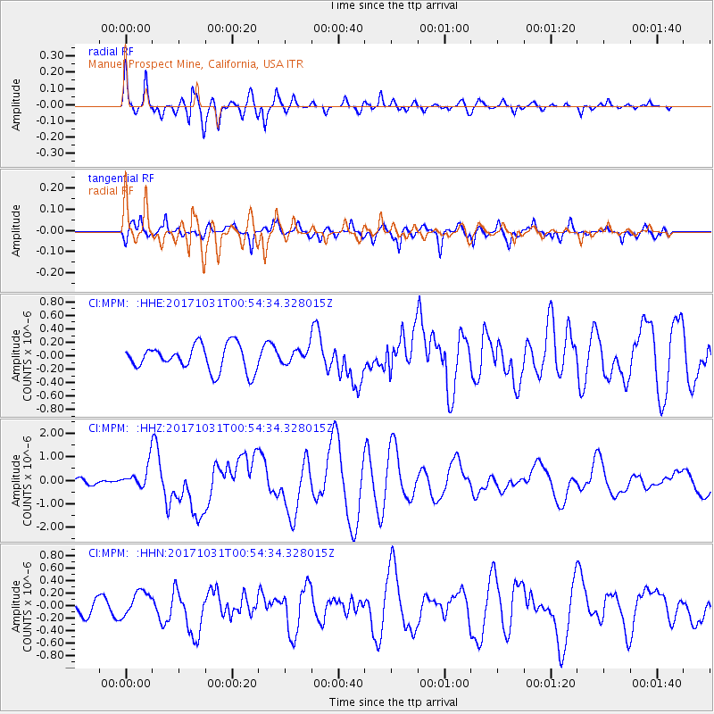
MPM Manuel Prospect Mine, California, USA - Earthquake Result Viewer
*The percent match for this event was below the threshold and hence no stack was calculated.
| Earthquake location: |
Southeast Of Loyalty Islands |
| Earthquake latitude/longitude: |
-21.7/169.2 |
| Earthquake time(UTC): |
2017/10/31 (304) 00:42:06 GMT |
| Earthquake Depth: |
9.1 km |
| Earthquake Magnitude: |
6.8 Mww |
| Earthquake Catalog/Contributor: |
NEIC PDE/us |
|
| Network: |
CI Caltech Regional Seismic Network |
| Station: |
MPM Manuel Prospect Mine, California, USA |
| Lat/Lon: |
36.06 N/117.49 W |
| Elevation: |
185 m |
|
| Distance: |
89.9 deg |
| Az: |
50.908 deg |
| Baz: |
242.997 deg |
| Ray Param: |
$rayparam |
*The percent match for this event was below the threshold and hence was not used in the summary stack. |
|
| Radial Match: |
79.158516 % |
| Radial Bump: |
400 |
| Transverse Match: |
74.781906 % |
| Transverse Bump: |
400 |
| SOD ConfigId: |
13570011 |
| Insert Time: |
2019-04-29 01:17:56.730 +0000 |
| GWidth: |
2.5 |
| Max Bumps: |
400 |
| Tol: |
0.001 |
|
Signal To Noise
| Channel | StoN | STA | LTA |
| CI:MPM: :HHZ:20171031T00:54:34.328015Z | 2.6203604 | 5.1104047E-7 | 1.9502679E-7 |
| CI:MPM: :HHN:20171031T00:54:34.328015Z | 2.0251508 | 2.0694246E-7 | 1.021862E-7 |
| CI:MPM: :HHE:20171031T00:54:34.328015Z | 0.56322694 | 1.0651689E-7 | 1.8911896E-7 |
| Arrivals |
| Ps | |
| PpPs | |
| PsPs/PpSs | |


