You are here: Home > Network List > CI - Caltech Regional Seismic Network Stations List
> Station SMM Simmler, CA, USA > Earthquake Result Viewer
SMM Simmler, CA, USA - Earthquake Result Viewer
*The percent match for this event was below the threshold and hence no stack was calculated.
| Earthquake location: |
Southeast Of Loyalty Islands |
| Earthquake latitude/longitude: |
-21.7/169.2 |
| Earthquake time(UTC): |
2017/10/31 (304) 00:42:06 GMT |
| Earthquake Depth: |
9.1 km |
| Earthquake Magnitude: |
6.8 Mww |
| Earthquake Catalog/Contributor: |
NEIC PDE/us |
|
| Network: |
CI Caltech Regional Seismic Network |
| Station: |
SMM Simmler, CA, USA |
| Lat/Lon: |
35.31 N/120.00 W |
| Elevation: |
599 m |
|
| Distance: |
87.8 deg |
| Az: |
50.615 deg |
| Baz: |
241.535 deg |
| Ray Param: |
$rayparam |
*The percent match for this event was below the threshold and hence was not used in the summary stack. |
|
| Radial Match: |
78.480156 % |
| Radial Bump: |
400 |
| Transverse Match: |
40.10252 % |
| Transverse Bump: |
400 |
| SOD ConfigId: |
13570011 |
| Insert Time: |
2019-04-29 01:18:08.551 +0000 |
| GWidth: |
2.5 |
| Max Bumps: |
400 |
| Tol: |
0.001 |
|
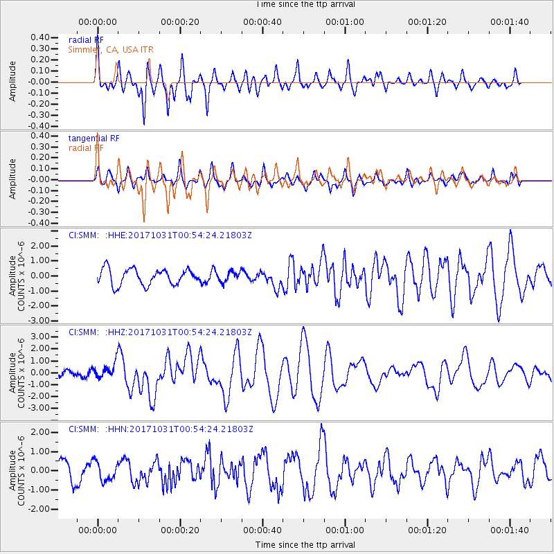
Signal To Noise
| Channel | StoN | STA | LTA |
| CI:SMM: :HHZ:20171031T00:54:24.21803Z | 2.743437 | 6.912157E-7 | 2.5195246E-7 |
| CI:SMM: :HHN:20171031T00:54:24.21803Z | 0.8532524 | 4.791224E-7 | 5.615248E-7 |
| CI:SMM: :HHE:20171031T00:54:24.21803Z | 0.6274158 | 3.333638E-7 | 5.313284E-7 |
| Arrivals |
| Ps | |
| PpPs | |
| PsPs/PpSs | |


