You are here: Home > Network List > TA - USArray Transportable Network (new EarthScope stations) Stations List
> Station T18A Mexican Hat, UT, USA > Earthquake Result Viewer
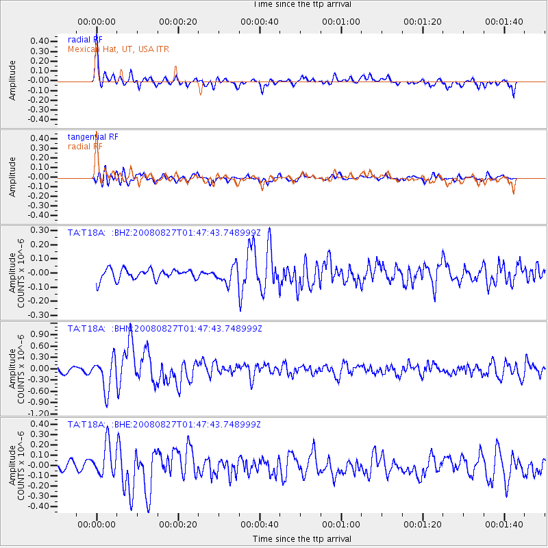
T18A Mexican Hat, UT, USA - Earthquake Result Viewer
*The percent match for this event was below the threshold and hence no stack was calculated.
| Earthquake location: |
Lake Baykal Region, Russia |
| Earthquake latitude/longitude: |
51.6/104.2 |
| Earthquake time(UTC): |
2008/08/27 (240) 01:35:32 GMT |
| Earthquake Depth: |
16 km |
| Earthquake Magnitude: |
5.8 MB, 6.2 MS, 6.2 MW, 6.2 MW |
| Earthquake Catalog/Contributor: |
WHDF/NEIC |
|
| Network: |
TA USArray Transportable Network (new EarthScope stations) |
| Station: |
T18A Mexican Hat, UT, USA |
| Lat/Lon: |
37.14 N/109.87 W |
| Elevation: |
1297 m |
|
| Distance: |
86.7 deg |
| Az: |
26.614 deg |
| Baz: |
339.539 deg |
| Ray Param: |
$rayparam |
*The percent match for this event was below the threshold and hence was not used in the summary stack. |
|
| Radial Match: |
78.15097 % |
| Radial Bump: |
400 |
| Transverse Match: |
72.0709 % |
| Transverse Bump: |
400 |
| SOD ConfigId: |
2504 |
| Insert Time: |
2010-03-06 05:36:56.399 +0000 |
| GWidth: |
2.5 |
| Max Bumps: |
400 |
| Tol: |
0.001 |
|
Signal To Noise
| Channel | StoN | STA | LTA |
| TA:T18A: :BHN:20080827T01:47:43.748999Z | 4.808036 | 4.382212E-7 | 9.11435E-8 |
| TA:T18A: :BHE:20080827T01:47:43.748999Z | 4.2361207 | 1.7152313E-7 | 4.049061E-8 |
| TA:T18A: :BHZ:20080827T01:47:43.748999Z | 1.6789281 | 6.181601E-8 | 3.6818733E-8 |
| Arrivals |
| Ps | |
| PpPs | |
| PsPs/PpSs | |


