You are here: Home > Network List > NN - Western Great Basin/Eastern Sierra Nevada Stations List
> Station LHV Little Huntoon Valley, Nevada w84gm > Earthquake Result Viewer
LHV Little Huntoon Valley, Nevada w84gm - Earthquake Result Viewer
| Earthquake location: |
Southeast Of Loyalty Islands |
| Earthquake latitude/longitude: |
-21.7/169.2 |
| Earthquake time(UTC): |
2017/10/31 (304) 00:42:06 GMT |
| Earthquake Depth: |
9.1 km |
| Earthquake Magnitude: |
6.8 Mww |
| Earthquake Catalog/Contributor: |
NEIC PDE/us |
|
| Network: |
NN Western Great Basin/Eastern Sierra Nevada |
| Station: |
LHV Little Huntoon Valley, Nevada w84gm |
| Lat/Lon: |
38.25 N/118.50 W |
| Elevation: |
2353 m |
|
| Distance: |
90.2 deg |
| Az: |
48.59 deg |
| Baz: |
242.388 deg |
| Ray Param: |
0.04169062 |
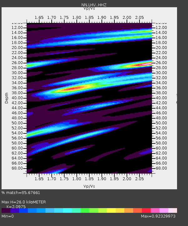
| Estimated Moho Depth: |
26.0 km |
| Estimated Crust Vp/Vs: |
2.10 |
| Assumed Crust Vp: |
6.279 km/s |
| Estimated Crust Vs: |
2.993 km/s |
| Estimated Crust Poisson's Ratio: |
0.35 |
|
| Radial Match: |
85.67661 % |
| Radial Bump: |
400 |
| Transverse Match: |
76.22636 % |
| Transverse Bump: |
400 |
| SOD ConfigId: |
13570011 |
| Insert Time: |
2019-04-29 01:19:06.652 +0000 |
| GWidth: |
2.5 |
| Max Bumps: |
400 |
| Tol: |
0.001 |
|

Signal To Noise
| Channel | StoN | STA | LTA |
| NN:LHV: :HHZ:20171031T00:54:35.638013Z | 3.8570898 | 4.3244108E-7 | 1.121159E-7 |
| NN:LHV: :HHN:20171031T00:54:35.638013Z | 1.0594207 | 2.090571E-7 | 1.9733153E-7 |
| NN:LHV: :HHE:20171031T00:54:35.638013Z | 0.614896 | 1.362539E-7 | 2.2158854E-7 |
| Arrivals |
| Ps | 4.6 SECOND |
| PpPs | 13 SECOND |
| PsPs/PpSs | 17 SECOND |


