You are here: Home > Network List > TA - USArray Transportable Network (new EarthScope stations) Stations List
> Station F26K Sheenjek River, AK, USA > Earthquake Result Viewer
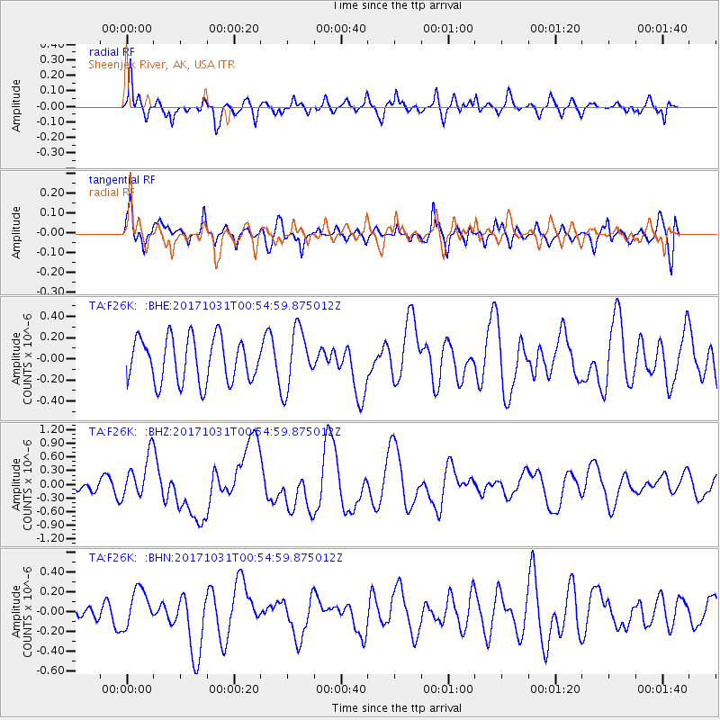
F26K Sheenjek River, AK, USA - Earthquake Result Viewer
*The percent match for this event was below the threshold and hence no stack was calculated.
| Earthquake location: |
Southeast Of Loyalty Islands |
| Earthquake latitude/longitude: |
-21.7/169.2 |
| Earthquake time(UTC): |
2017/10/31 (304) 00:42:06 GMT |
| Earthquake Depth: |
9.1 km |
| Earthquake Magnitude: |
6.8 Mww |
| Earthquake Catalog/Contributor: |
NEIC PDE/us |
|
| Network: |
TA USArray Transportable Network (new EarthScope stations) |
| Station: |
F26K Sheenjek River, AK, USA |
| Lat/Lon: |
67.69 N/144.15 W |
| Elevation: |
683 m |
|
| Distance: |
95.5 deg |
| Az: |
16.191 deg |
| Baz: |
222.803 deg |
| Ray Param: |
$rayparam |
*The percent match for this event was below the threshold and hence was not used in the summary stack. |
|
| Radial Match: |
63.065277 % |
| Radial Bump: |
400 |
| Transverse Match: |
53.934258 % |
| Transverse Bump: |
400 |
| SOD ConfigId: |
13570011 |
| Insert Time: |
2019-04-29 01:20:23.175 +0000 |
| GWidth: |
2.5 |
| Max Bumps: |
400 |
| Tol: |
0.001 |
|
Signal To Noise
| Channel | StoN | STA | LTA |
| TA:F26K: :BHZ:20171031T00:54:59.875012Z | 2.4656363 | 4.825316E-7 | 1.9570268E-7 |
| TA:F26K: :BHN:20171031T00:54:59.875012Z | 1.1897916 | 1.9151771E-7 | 1.6096745E-7 |
| TA:F26K: :BHE:20171031T00:54:59.875012Z | 1.3309168 | 2.7642292E-7 | 2.0769363E-7 |
| Arrivals |
| Ps | |
| PpPs | |
| PsPs/PpSs | |


