You are here: Home > Network List > TA - USArray Transportable Network (new EarthScope stations) Stations List
> Station J16K Anvik River, AK, USA > Earthquake Result Viewer
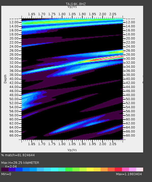
J16K Anvik River, AK, USA - Earthquake Result Viewer
| Earthquake location: |
Southeast Of Loyalty Islands |
| Earthquake latitude/longitude: |
-21.7/169.2 |
| Earthquake time(UTC): |
2017/10/31 (304) 00:42:06 GMT |
| Earthquake Depth: |
9.1 km |
| Earthquake Magnitude: |
6.8 Mww |
| Earthquake Catalog/Contributor: |
NEIC PDE/us |
|
| Network: |
TA USArray Transportable Network (new EarthScope stations) |
| Station: |
J16K Anvik River, AK, USA |
| Lat/Lon: |
63.28 N/160.60 W |
| Elevation: |
328 m |
|
| Distance: |
87.9 deg |
| Az: |
13.146 deg |
| Baz: |
207.908 deg |
| Ray Param: |
0.04296092 |
| Estimated Moho Depth: |
29.25 km |
| Estimated Crust Vp/Vs: |
2.04 |
| Assumed Crust Vp: |
6.276 km/s |
| Estimated Crust Vs: |
3.076 km/s |
| Estimated Crust Poisson's Ratio: |
0.34 |
|
| Radial Match: |
81.924644 % |
| Radial Bump: |
369 |
| Transverse Match: |
59.2024 % |
| Transverse Bump: |
400 |
| SOD ConfigId: |
13570011 |
| Insert Time: |
2019-04-29 01:20:43.150 +0000 |
| GWidth: |
2.5 |
| Max Bumps: |
400 |
| Tol: |
0.001 |
|

Signal To Noise
| Channel | StoN | STA | LTA |
| TA:J16K: :BHZ:20171031T00:54:25.050Z | 3.31182 | 7.897484E-7 | 2.3846357E-7 |
| TA:J16K: :BHN:20171031T00:54:25.050Z | 1.1822288 | 3.9941997E-7 | 3.3785335E-7 |
| TA:J16K: :BHE:20171031T00:54:25.050Z | 1.6316434 | 4.52784E-7 | 2.775018E-7 |
| Arrivals |
| Ps | 4.9 SECOND |
| PpPs | 14 SECOND |
| PsPs/PpSs | 19 SECOND |


