You are here: Home > Network List > UU - University of Utah Regional Network Stations List
> Station KNB Kanab, UT, USA > Earthquake Result Viewer
KNB Kanab, UT, USA - Earthquake Result Viewer
| Earthquake location: |
Near East Coast Of Kamchatka |
| Earthquake latitude/longitude: |
54.3/162.8 |
| Earthquake time(UTC): |
2016/03/20 (080) 22:50:20 GMT |
| Earthquake Depth: |
31 km |
| Earthquake Magnitude: |
6.4 MWC, 6.2 MWB, 6.6 MI |
| Earthquake Catalog/Contributor: |
NEIC PDE/NEIC COMCAT |
|
| Network: |
UU University of Utah Regional Network |
| Station: |
KNB Kanab, UT, USA |
| Lat/Lon: |
37.02 N/112.82 W |
| Elevation: |
1715 m |
|
| Distance: |
57.9 deg |
| Az: |
70.151 deg |
| Baz: |
316.509 deg |
| Ray Param: |
0.06316016 |
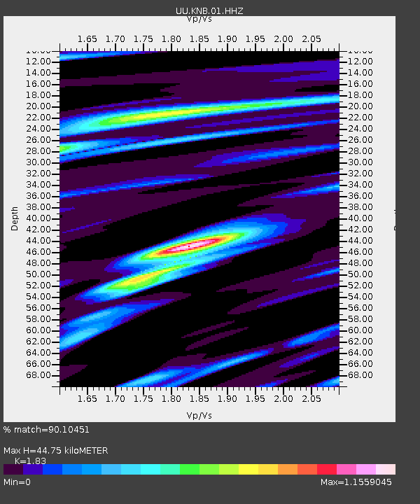
| Estimated Moho Depth: |
44.75 km |
| Estimated Crust Vp/Vs: |
1.83 |
| Assumed Crust Vp: |
6.194 km/s |
| Estimated Crust Vs: |
3.385 km/s |
| Estimated Crust Poisson's Ratio: |
0.29 |
|
| Radial Match: |
90.10451 % |
| Radial Bump: |
311 |
| Transverse Match: |
86.13384 % |
| Transverse Bump: |
370 |
| SOD ConfigId: |
1464191 |
| Insert Time: |
2016-04-03 23:21:29.353 +0000 |
| GWidth: |
2.5 |
| Max Bumps: |
400 |
| Tol: |
0.001 |
|

Signal To Noise
| Channel | StoN | STA | LTA |
| UU:KNB:01:HHZ:20160320T22:59:38.73001Z | 3.5174143 | 2.6610422E-8 | 7.565337E-9 |
| UU:KNB:01:HHN:20160320T22:59:38.73001Z | 1.3640224 | 8.499204E-9 | 6.230986E-9 |
| UU:KNB:01:HHE:20160320T22:59:38.73001Z | 0.67890567 | 4.999699E-9 | 7.36435E-9 |
| Arrivals |
| Ps | 6.3 SECOND |
| PpPs | 20 SECOND |
| PsPs/PpSs | 26 SECOND |


