You are here: Home > Network List > UU - University of Utah Regional Network Stations List
> Station PKCU Pink Cliffs, UT, USA > Earthquake Result Viewer
PKCU Pink Cliffs, UT, USA - Earthquake Result Viewer
| Earthquake location: |
Near East Coast Of Kamchatka |
| Earthquake latitude/longitude: |
54.3/162.8 |
| Earthquake time(UTC): |
2016/03/20 (080) 22:50:20 GMT |
| Earthquake Depth: |
31 km |
| Earthquake Magnitude: |
6.4 MWC, 6.2 MWB, 6.6 MI |
| Earthquake Catalog/Contributor: |
NEIC PDE/NEIC COMCAT |
|
| Network: |
UU University of Utah Regional Network |
| Station: |
PKCU Pink Cliffs, UT, USA |
| Lat/Lon: |
37.44 N/112.31 W |
| Elevation: |
2834 m |
|
| Distance: |
57.8 deg |
| Az: |
69.455 deg |
| Baz: |
316.446 deg |
| Ray Param: |
0.06317865 |
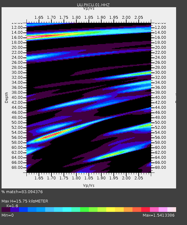
| Estimated Moho Depth: |
15.75 km |
| Estimated Crust Vp/Vs: |
1.60 |
| Assumed Crust Vp: |
6.194 km/s |
| Estimated Crust Vs: |
3.871 km/s |
| Estimated Crust Poisson's Ratio: |
0.18 |
|
| Radial Match: |
83.094376 % |
| Radial Bump: |
327 |
| Transverse Match: |
70.03071 % |
| Transverse Bump: |
395 |
| SOD ConfigId: |
1464191 |
| Insert Time: |
2016-04-03 23:21:56.075 +0000 |
| GWidth: |
2.5 |
| Max Bumps: |
400 |
| Tol: |
0.001 |
|

Signal To Noise
| Channel | StoN | STA | LTA |
| UU:PKCU:01:HHZ:20160320T22:59:38.529998Z | 3.0558019 | 2.0495827E-8 | 6.707185E-9 |
| UU:PKCU:01:HHN:20160320T22:59:38.529998Z | 0.668717 | 1.248966E-8 | 1.8677047E-8 |
| UU:PKCU:01:HHE:20160320T22:59:38.529998Z | 0.4892518 | 1.0080678E-8 | 2.0604274E-8 |
| Arrivals |
| Ps | 1.6 SECOND |
| PpPs | 6.3 SECOND |
| PsPs/PpSs | 7.9 SECOND |


