You are here: Home > Network List > UW - Pacific Northwest Regional Seismic Network Stations List
> Station YACT Amboy, WA, USA > Earthquake Result Viewer
YACT Amboy, WA, USA - Earthquake Result Viewer
*The percent match for this event was below the threshold and hence no stack was calculated.
| Earthquake location: |
Southeast Of Loyalty Islands |
| Earthquake latitude/longitude: |
-21.7/169.2 |
| Earthquake time(UTC): |
2017/10/31 (304) 00:42:06 GMT |
| Earthquake Depth: |
9.1 km |
| Earthquake Magnitude: |
6.8 Mww |
| Earthquake Catalog/Contributor: |
NEIC PDE/us |
|
| Network: |
UW Pacific Northwest Regional Seismic Network |
| Station: |
YACT Amboy, WA, USA |
| Lat/Lon: |
45.93 N/122.42 W |
| Elevation: |
211 m |
|
| Distance: |
91.4 deg |
| Az: |
40.463 deg |
| Baz: |
239.878 deg |
| Ray Param: |
$rayparam |
*The percent match for this event was below the threshold and hence was not used in the summary stack. |
|
| Radial Match: |
79.842255 % |
| Radial Bump: |
335 |
| Transverse Match: |
70.85653 % |
| Transverse Bump: |
400 |
| SOD ConfigId: |
13570011 |
| Insert Time: |
2019-04-29 01:22:23.506 +0000 |
| GWidth: |
2.5 |
| Max Bumps: |
400 |
| Tol: |
0.001 |
|
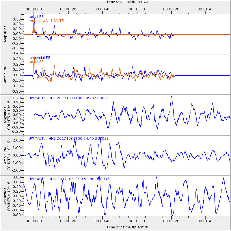
Signal To Noise
| Channel | StoN | STA | LTA |
| UW:YACT: :HHZ:20171031T00:54:40.96803Z | 4.0349407 | 7.295985E-7 | 1.8082012E-7 |
| UW:YACT: :HHN:20171031T00:54:40.96803Z | 2.2164173 | 4.1702148E-7 | 1.8815116E-7 |
| UW:YACT: :HHE:20171031T00:54:40.96803Z | 2.067598 | 2.9290962E-7 | 1.4166662E-7 |
| Arrivals |
| Ps | |
| PpPs | |
| PsPs/PpSs | |


