You are here: Home > Network List > TA - USArray Transportable Network (new EarthScope stations) Stations List
> Station N16A Rees Ranch, Coalville, UT, USA > Earthquake Result Viewer
N16A Rees Ranch, Coalville, UT, USA - Earthquake Result Viewer

| Earthquake location: |
Andreanof Islands, Aleutian Is. |
| Earthquake latitude/longitude: |
51.9/-177.5 |
| Earthquake time(UTC): |
2008/05/02 (123) 01:33:37 GMT |
| Earthquake Depth: |
14 km |
| Earthquake Magnitude: |
6.3 MB, 6.8 MS, 6.6 MW, 6.6 MW |
| Earthquake Catalog/Contributor: |
WHDF/NEIC |
|
| Network: |
TA USArray Transportable Network (new EarthScope stations) |
| Station: |
N16A Rees Ranch, Coalville, UT, USA |
| Lat/Lon: |
40.89 N/111.44 W |
| Elevation: |
2028 m |
|
| Distance: |
45.4 deg |
| Az: |
76.745 deg |
| Baz: |
307.241 deg |
| Ray Param: |
0.07128922 |
| Estimated Moho Depth: |
58.25 km |
| Estimated Crust Vp/Vs: |
1.96 |
| Assumed Crust Vp: |
6.155 km/s |
| Estimated Crust Vs: |
3.14 km/s |
| Estimated Crust Poisson's Ratio: |
0.32 |
|
| Radial Match: |
83.832825 % |
| Radial Bump: |
400 |
| Transverse Match: |
69.933784 % |
| Transverse Bump: |
400 |
| SOD ConfigId: |
2504 |
| Insert Time: |
2010-03-06 05:38:09.522 +0000 |
| GWidth: |
2.5 |
| Max Bumps: |
400 |
| Tol: |
0.001 |
|
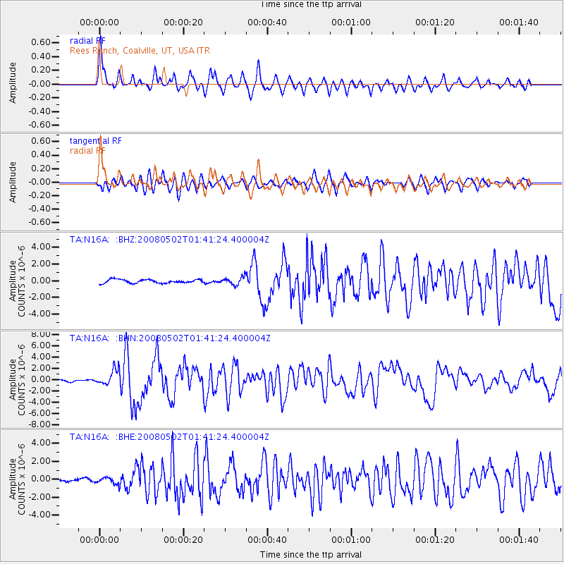
Signal To Noise
| Channel | StoN | STA | LTA |
| TA:N16A: :BHN:20080502T01:41:24.400004Z | 6.66153 | 1.4284161E-6 | 2.1442763E-7 |
| TA:N16A: :BHE:20080502T01:41:24.400004Z | 1.562747 | 3.8829526E-7 | 2.484697E-7 |
| TA:N16A: :BHZ:20080502T01:41:24.400004Z | 2.147434 | 4.6507657E-7 | 2.1657316E-7 |
| Arrivals |
| Ps | 9.6 SECOND |
| PpPs | 27 SECOND |
| PsPs/PpSs | 36 SECOND |


