You are here: Home > Network List > UU - University of Utah Regional Network Stations List
> Station SRU San Rafael Swell, UT, USA > Earthquake Result Viewer
SRU San Rafael Swell, UT, USA - Earthquake Result Viewer
| Earthquake location: |
Near East Coast Of Kamchatka |
| Earthquake latitude/longitude: |
54.3/162.8 |
| Earthquake time(UTC): |
2016/03/20 (080) 22:50:20 GMT |
| Earthquake Depth: |
31 km |
| Earthquake Magnitude: |
6.4 MWC, 6.2 MWB, 6.6 MI |
| Earthquake Catalog/Contributor: |
NEIC PDE/NEIC COMCAT |
|
| Network: |
UU University of Utah Regional Network |
| Station: |
SRU San Rafael Swell, UT, USA |
| Lat/Lon: |
39.11 N/110.52 W |
| Elevation: |
1804 m |
|
| Distance: |
57.6 deg |
| Az: |
66.892 deg |
| Baz: |
316.18 deg |
| Ray Param: |
0.063327834 |
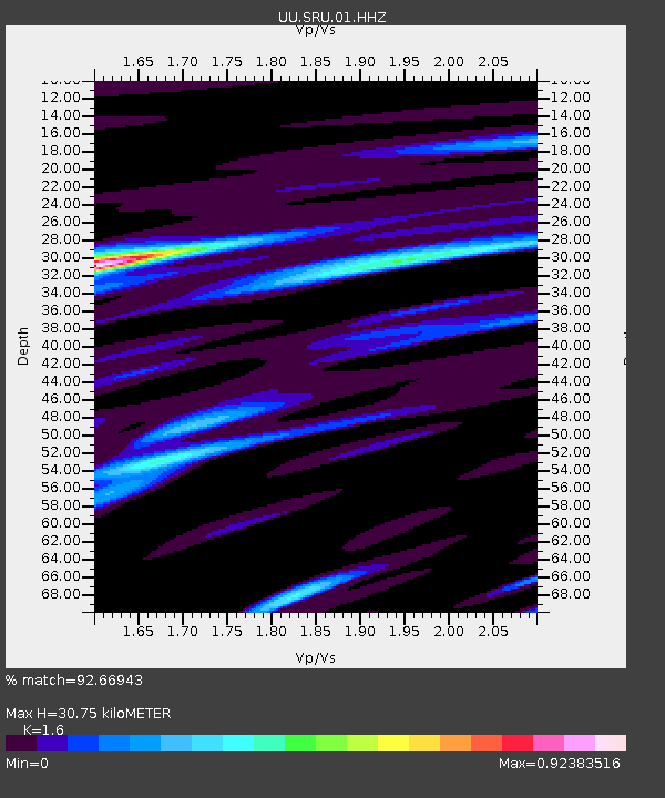
| Estimated Moho Depth: |
30.75 km |
| Estimated Crust Vp/Vs: |
1.60 |
| Assumed Crust Vp: |
6.207 km/s |
| Estimated Crust Vs: |
3.879 km/s |
| Estimated Crust Poisson's Ratio: |
0.18 |
|
| Radial Match: |
92.66943 % |
| Radial Bump: |
400 |
| Transverse Match: |
84.78887 % |
| Transverse Bump: |
400 |
| SOD ConfigId: |
1464191 |
| Insert Time: |
2016-04-03 23:22:30.969 +0000 |
| GWidth: |
2.5 |
| Max Bumps: |
400 |
| Tol: |
0.001 |
|

Signal To Noise
| Channel | StoN | STA | LTA |
| UU:SRU:01:HHZ:20160320T22:59:36.904998Z | 5.6033053 | 8.1142474E-7 | 1.4481179E-7 |
| UU:SRU:01:HHN:20160320T22:59:36.904998Z | 2.352892 | 3.488019E-7 | 1.4824391E-7 |
| UU:SRU:01:HHE:20160320T22:59:36.904998Z | 1.488622 | 2.2133435E-7 | 1.4868405E-7 |
| Arrivals |
| Ps | 3.1 SECOND |
| PpPs | 12 SECOND |
| PsPs/PpSs | 15 SECOND |


