You are here: Home > Network List > YT07 - POLENET Stations List
> Station ALYS ALYS > Earthquake Result Viewer
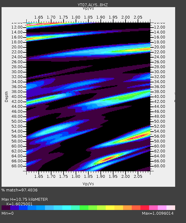
ALYS ALYS - Earthquake Result Viewer
| Earthquake location: |
Southeast Of Loyalty Islands |
| Earthquake latitude/longitude: |
-21.7/169.2 |
| Earthquake time(UTC): |
2017/10/31 (304) 00:42:06 GMT |
| Earthquake Depth: |
9.1 km |
| Earthquake Magnitude: |
6.8 Mww |
| Earthquake Catalog/Contributor: |
NEIC PDE/us |
|
| Network: |
YT POLENET |
| Station: |
ALYS ALYS |
| Lat/Lon: |
84.35 S/23.73 W |
| Elevation: |
2084 m |
|
| Distance: |
74.0 deg |
| Az: |
178.678 deg |
| Baz: |
192.518 deg |
| Ray Param: |
0.052622486 |
| Estimated Moho Depth: |
10.75 km |
| Estimated Crust Vp/Vs: |
1.60 |
| Assumed Crust Vp: |
6.356 km/s |
| Estimated Crust Vs: |
3.966 km/s |
| Estimated Crust Poisson's Ratio: |
0.18 |
|
| Radial Match: |
97.4836 % |
| Radial Bump: |
400 |
| Transverse Match: |
94.954 % |
| Transverse Bump: |
400 |
| SOD ConfigId: |
13570011 |
| Insert Time: |
2019-04-29 01:22:40.610 +0000 |
| GWidth: |
2.5 |
| Max Bumps: |
400 |
| Tol: |
0.001 |
|

Signal To Noise
| Channel | StoN | STA | LTA |
| YT:ALYS: :BHZ:20171031T00:53:11.123975Z | 5.0841975 | 6.171183E-7 | 1.2137968E-7 |
| YT:ALYS: :BHN:20171031T00:53:11.123975Z | 4.5852437 | 2.6961334E-7 | 5.8800214E-8 |
| YT:ALYS: :BHE:20171031T00:53:11.123975Z | 2.6347566 | 1.2304496E-7 | 4.670069E-8 |
| Arrivals |
| Ps | 1.1 SECOND |
| PpPs | 4.2 SECOND |
| PsPs/PpSs | 5.3 SECOND |


