You are here: Home > Network List > TA - USArray Transportable Network (new EarthScope stations) Stations List
> Station L15K Ungalak Mountain, AK, USA > Earthquake Result Viewer
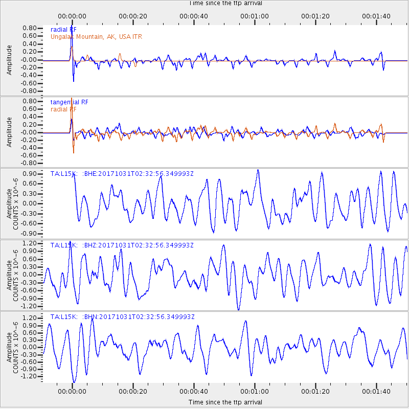
L15K Ungalak Mountain, AK, USA - Earthquake Result Viewer
*The percent match for this event was below the threshold and hence no stack was calculated.
| Earthquake location: |
Loyalty Islands |
| Earthquake latitude/longitude: |
-21.5/168.9 |
| Earthquake time(UTC): |
2017/10/31 (304) 02:20:46 GMT |
| Earthquake Depth: |
10 km |
| Earthquake Magnitude: |
5.9 Mww |
| Earthquake Catalog/Contributor: |
NEIC PDE/us |
|
| Network: |
TA USArray Transportable Network (new EarthScope stations) |
| Station: |
L15K Ungalak Mountain, AK, USA |
| Lat/Lon: |
61.68 N/161.49 W |
| Elevation: |
219 m |
|
| Distance: |
86.2 deg |
| Az: |
13.663 deg |
| Baz: |
207.474 deg |
| Ray Param: |
$rayparam |
*The percent match for this event was below the threshold and hence was not used in the summary stack. |
|
| Radial Match: |
63.270782 % |
| Radial Bump: |
400 |
| Transverse Match: |
43.242928 % |
| Transverse Bump: |
400 |
| SOD ConfigId: |
13570011 |
| Insert Time: |
2019-04-29 01:26:16.576 +0000 |
| GWidth: |
2.5 |
| Max Bumps: |
400 |
| Tol: |
0.001 |
|
Signal To Noise
| Channel | StoN | STA | LTA |
| TA:L15K: :BHZ:20171031T02:32:56.349993Z | 2.4099255 | 7.552778E-7 | 3.1340298E-7 |
| TA:L15K: :BHN:20171031T02:32:56.349993Z | 1.9872142 | 9.082863E-7 | 4.570651E-7 |
| TA:L15K: :BHE:20171031T02:32:56.349993Z | 0.99613637 | 3.6292892E-7 | 3.643366E-7 |
| Arrivals |
| Ps | |
| PpPs | |
| PsPs/PpSs | |


