You are here: Home > Network List > UW - Pacific Northwest Regional Seismic Network Stations List
> Station DDRF Dider Farm, Eltopia, WA, USA > Earthquake Result Viewer
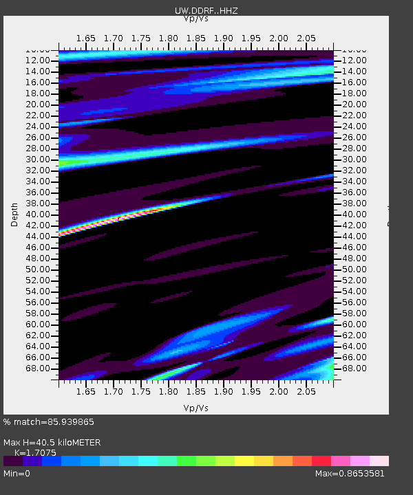
DDRF Dider Farm, Eltopia, WA, USA - Earthquake Result Viewer
| Earthquake location: |
Loyalty Islands |
| Earthquake latitude/longitude: |
-21.5/168.9 |
| Earthquake time(UTC): |
2017/10/31 (304) 02:20:46 GMT |
| Earthquake Depth: |
10 km |
| Earthquake Magnitude: |
5.9 Mww |
| Earthquake Catalog/Contributor: |
NEIC PDE/us |
|
| Network: |
UW Pacific Northwest Regional Seismic Network |
| Station: |
DDRF Dider Farm, Eltopia, WA, USA |
| Lat/Lon: |
46.49 N/119.06 W |
| Elevation: |
233 m |
|
| Distance: |
93.7 deg |
| Az: |
41.195 deg |
| Baz: |
242.617 deg |
| Ray Param: |
0.041207314 |
| Estimated Moho Depth: |
40.5 km |
| Estimated Crust Vp/Vs: |
1.71 |
| Assumed Crust Vp: |
6.419 km/s |
| Estimated Crust Vs: |
3.759 km/s |
| Estimated Crust Poisson's Ratio: |
0.24 |
|
| Radial Match: |
85.939865 % |
| Radial Bump: |
189 |
| Transverse Match: |
69.950195 % |
| Transverse Bump: |
400 |
| SOD ConfigId: |
13570011 |
| Insert Time: |
2019-04-29 01:26:50.094 +0000 |
| GWidth: |
2.5 |
| Max Bumps: |
400 |
| Tol: |
0.001 |
|

Signal To Noise
| Channel | StoN | STA | LTA |
| UW:DDRF: :HHZ:20171031T02:33:31.527971Z | 1.4856337 | 7.2100073E-7 | 4.8531524E-7 |
| UW:DDRF: :HHN:20171031T02:33:31.527971Z | 0.8462606 | 2.9593295E-7 | 3.496948E-7 |
| UW:DDRF: :HHE:20171031T02:33:31.527971Z | 1.7959245 | 6.898244E-7 | 3.8410542E-7 |
| Arrivals |
| Ps | 4.6 SECOND |
| PpPs | 17 SECOND |
| PsPs/PpSs | 21 SECOND |


