You are here: Home > Network List > UW - Pacific Northwest Regional Seismic Network Stations List
> Station UMAT Pilot Rock, OR, USA > Earthquake Result Viewer
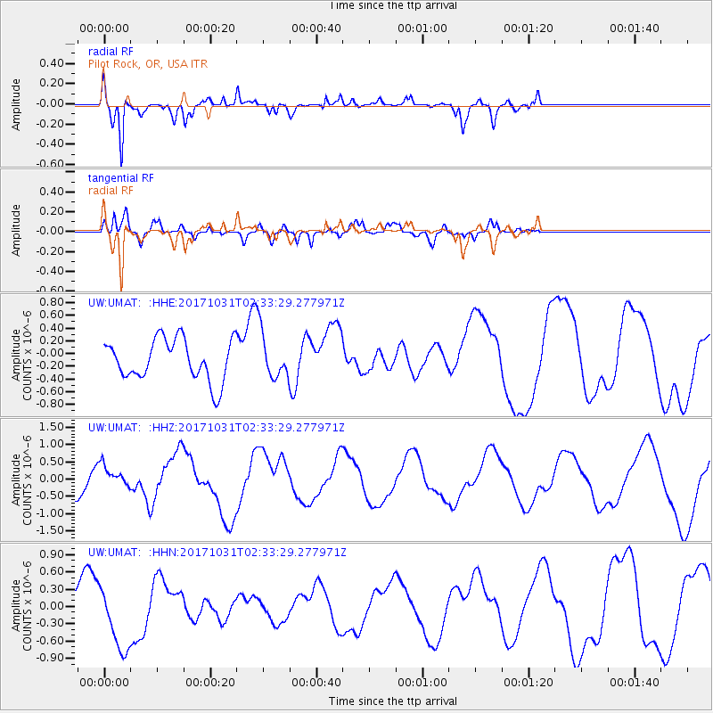
UMAT Pilot Rock, OR, USA - Earthquake Result Viewer
*The percent match for this event was below the threshold and hence no stack was calculated.
| Earthquake location: |
Loyalty Islands |
| Earthquake latitude/longitude: |
-21.5/168.9 |
| Earthquake time(UTC): |
2017/10/31 (304) 02:20:46 GMT |
| Earthquake Depth: |
10 km |
| Earthquake Magnitude: |
5.9 Mww |
| Earthquake Catalog/Contributor: |
NEIC PDE/us |
|
| Network: |
UW Pacific Northwest Regional Seismic Network |
| Station: |
UMAT Pilot Rock, OR, USA |
| Lat/Lon: |
45.29 N/118.96 W |
| Elevation: |
1318 m |
|
| Distance: |
93.2 deg |
| Az: |
42.296 deg |
| Baz: |
242.622 deg |
| Ray Param: |
$rayparam |
*The percent match for this event was below the threshold and hence was not used in the summary stack. |
|
| Radial Match: |
81.122345 % |
| Radial Bump: |
303 |
| Transverse Match: |
60.342693 % |
| Transverse Bump: |
353 |
| SOD ConfigId: |
13570011 |
| Insert Time: |
2019-04-29 01:26:56.634 +0000 |
| GWidth: |
2.5 |
| Max Bumps: |
400 |
| Tol: |
0.001 |
|
Signal To Noise
| Channel | StoN | STA | LTA |
| UW:UMAT: :HHZ:20171031T02:33:29.277971Z | 0.76506996 | 3.0952467E-7 | 4.0457044E-7 |
| UW:UMAT: :HHN:20171031T02:33:29.277971Z | 1.7991332 | 5.58341E-7 | 3.103389E-7 |
| UW:UMAT: :HHE:20171031T02:33:29.277971Z | 1.1025124 | 3.5544335E-7 | 3.22394E-7 |
| Arrivals |
| Ps | |
| PpPs | |
| PsPs/PpSs | |


