You are here: Home > Network List > TA - USArray Transportable Network (new EarthScope stations) Stations List
> Station N16A Rees Ranch, Coalville, UT, USA > Earthquake Result Viewer
N16A Rees Ranch, Coalville, UT, USA - Earthquake Result Viewer

| Earthquake location: |
Fox Islands, Aleutian Islands |
| Earthquake latitude/longitude: |
52.5/-168.0 |
| Earthquake time(UTC): |
2007/07/15 (196) 13:08:00 GMT |
| Earthquake Depth: |
10 km |
| Earthquake Magnitude: |
5.8 MB, 5.9 MS, 6.1 MW, 6.0 MW |
| Earthquake Catalog/Contributor: |
WHDF/NEIC |
|
| Network: |
TA USArray Transportable Network (new EarthScope stations) |
| Station: |
N16A Rees Ranch, Coalville, UT, USA |
| Lat/Lon: |
40.89 N/111.44 W |
| Elevation: |
2028 m |
|
| Distance: |
39.5 deg |
| Az: |
83.806 deg |
| Baz: |
306.679 deg |
| Ray Param: |
0.074919626 |
| Estimated Moho Depth: |
66.75 km |
| Estimated Crust Vp/Vs: |
1.72 |
| Assumed Crust Vp: |
6.155 km/s |
| Estimated Crust Vs: |
3.589 km/s |
| Estimated Crust Poisson's Ratio: |
0.24 |
|
| Radial Match: |
81.4702 % |
| Radial Bump: |
400 |
| Transverse Match: |
68.4181 % |
| Transverse Bump: |
400 |
| SOD ConfigId: |
2564 |
| Insert Time: |
2010-03-06 05:39:17.231 +0000 |
| GWidth: |
2.5 |
| Max Bumps: |
400 |
| Tol: |
0.001 |
|
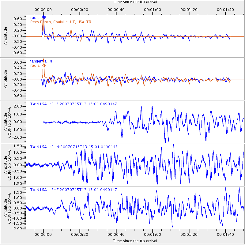
Signal To Noise
| Channel | StoN | STA | LTA |
| TA:N16A: :BHN:20070715T13:15:01.049014Z | 0.85994166 | 1.0381325E-7 | 1.2072127E-7 |
| TA:N16A: :BHE:20070715T13:15:01.049014Z | 0.8373895 | 1.2049462E-7 | 1.4389315E-7 |
| TA:N16A: :BHZ:20070715T13:15:01.049014Z | 3.6175613 | 1.9927333E-7 | 5.508499E-8 |
| Arrivals |
| Ps | 8.3 SECOND |
| PpPs | 28 SECOND |
| PsPs/PpSs | 36 SECOND |


