You are here: Home > Network List > CI - Caltech Regional Seismic Network Stations List
> Station MPM Manuel Prospect Mine, California, USA > Earthquake Result Viewer
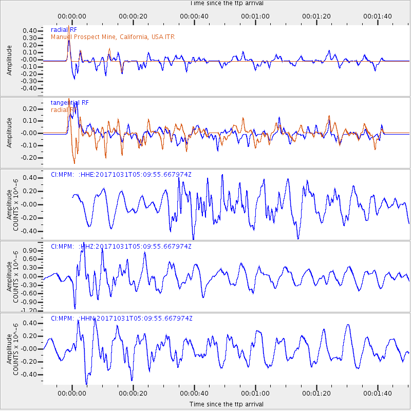
MPM Manuel Prospect Mine, California, USA - Earthquake Result Viewer
*The percent match for this event was below the threshold and hence no stack was calculated.
| Earthquake location: |
Tonga Islands |
| Earthquake latitude/longitude: |
-15.5/-173.3 |
| Earthquake time(UTC): |
2017/10/31 (304) 04:58:58 GMT |
| Earthquake Depth: |
35 km |
| Earthquake Magnitude: |
5.8 mb |
| Earthquake Catalog/Contributor: |
NEIC PDE/us |
|
| Network: |
CI Caltech Regional Seismic Network |
| Station: |
MPM Manuel Prospect Mine, California, USA |
| Lat/Lon: |
36.06 N/117.49 W |
| Elevation: |
185 m |
|
| Distance: |
73.6 deg |
| Az: |
44.343 deg |
| Baz: |
236.252 deg |
| Ray Param: |
$rayparam |
*The percent match for this event was below the threshold and hence was not used in the summary stack. |
|
| Radial Match: |
82.76472 % |
| Radial Bump: |
400 |
| Transverse Match: |
65.97548 % |
| Transverse Bump: |
400 |
| SOD ConfigId: |
13570011 |
| Insert Time: |
2019-04-29 01:29:38.305 +0000 |
| GWidth: |
2.5 |
| Max Bumps: |
400 |
| Tol: |
0.001 |
|
Signal To Noise
| Channel | StoN | STA | LTA |
| CI:MPM: :HHZ:20171031T05:09:55.667974Z | 1.9526025 | 6.1088724E-7 | 3.1285794E-7 |
| CI:MPM: :HHN:20171031T05:09:55.667974Z | 1.1561006 | 2.562936E-7 | 2.2168796E-7 |
| CI:MPM: :HHE:20171031T05:09:55.667974Z | 1.3888115 | 2.1673809E-7 | 1.5606011E-7 |
| Arrivals |
| Ps | |
| PpPs | |
| PsPs/PpSs | |


