You are here: Home > Network List > CI - Caltech Regional Seismic Network Stations List
> Station MUR Murrieta > Earthquake Result Viewer
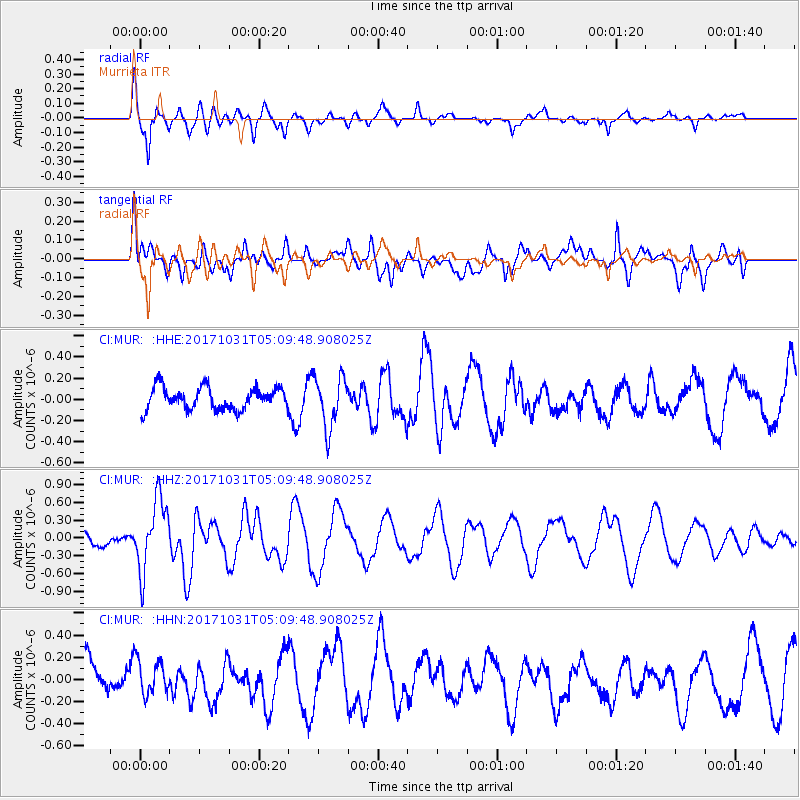
MUR Murrieta - Earthquake Result Viewer
*The percent match for this event was below the threshold and hence no stack was calculated.
| Earthquake location: |
Tonga Islands |
| Earthquake latitude/longitude: |
-15.5/-173.3 |
| Earthquake time(UTC): |
2017/10/31 (304) 04:58:58 GMT |
| Earthquake Depth: |
35 km |
| Earthquake Magnitude: |
5.8 mb |
| Earthquake Catalog/Contributor: |
NEIC PDE/us |
|
| Network: |
CI Caltech Regional Seismic Network |
| Station: |
MUR Murrieta |
| Lat/Lon: |
33.60 N/117.20 W |
| Elevation: |
562 m |
|
| Distance: |
72.4 deg |
| Az: |
46.624 deg |
| Baz: |
237.086 deg |
| Ray Param: |
$rayparam |
*The percent match for this event was below the threshold and hence was not used in the summary stack. |
|
| Radial Match: |
61.31366 % |
| Radial Bump: |
363 |
| Transverse Match: |
54.983334 % |
| Transverse Bump: |
400 |
| SOD ConfigId: |
13570011 |
| Insert Time: |
2019-04-29 01:29:39.435 +0000 |
| GWidth: |
2.5 |
| Max Bumps: |
400 |
| Tol: |
0.001 |
|
Signal To Noise
| Channel | StoN | STA | LTA |
| CI:MUR: :HHZ:20171031T05:09:48.908025Z | 4.971373 | 5.998803E-7 | 1.2066693E-7 |
| CI:MUR: :HHN:20171031T05:09:48.908025Z | 0.9347048 | 1.5328621E-7 | 1.6399424E-7 |
| CI:MUR: :HHE:20171031T05:09:48.908025Z | 2.1029449 | 2.2445302E-7 | 1.0673272E-7 |
| Arrivals |
| Ps | |
| PpPs | |
| PsPs/PpSs | |


