You are here: Home > Network List > CN - Canadian National Seismograph Network Stations List
> Station INK INUVIK, NT > Earthquake Result Viewer
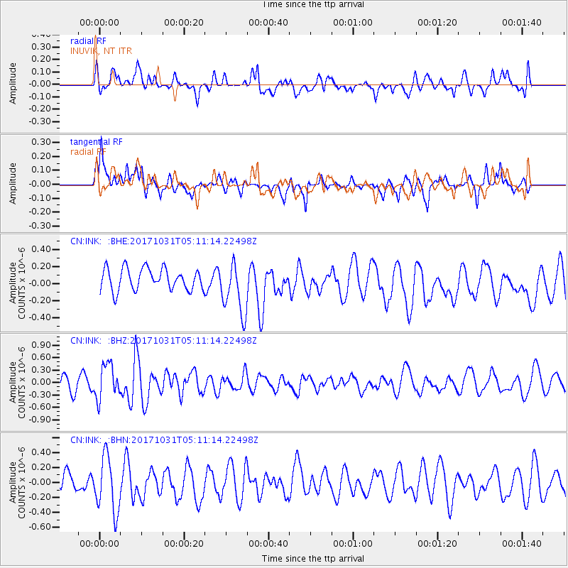
INK INUVIK, NT - Earthquake Result Viewer
*The percent match for this event was below the threshold and hence no stack was calculated.
| Earthquake location: |
Tonga Islands |
| Earthquake latitude/longitude: |
-15.5/-173.3 |
| Earthquake time(UTC): |
2017/10/31 (304) 04:58:58 GMT |
| Earthquake Depth: |
35 km |
| Earthquake Magnitude: |
5.8 mb |
| Earthquake Catalog/Contributor: |
NEIC PDE/us |
|
| Network: |
CN Canadian National Seismograph Network |
| Station: |
INK INUVIK, NT |
| Lat/Lon: |
68.31 N/133.53 W |
| Elevation: |
44 m |
|
| Distance: |
88.4 deg |
| Az: |
13.772 deg |
| Baz: |
218.113 deg |
| Ray Param: |
$rayparam |
*The percent match for this event was below the threshold and hence was not used in the summary stack. |
|
| Radial Match: |
43.580395 % |
| Radial Bump: |
400 |
| Transverse Match: |
34.886353 % |
| Transverse Bump: |
400 |
| SOD ConfigId: |
13570011 |
| Insert Time: |
2019-04-29 01:30:06.096 +0000 |
| GWidth: |
2.5 |
| Max Bumps: |
400 |
| Tol: |
0.001 |
|
Signal To Noise
| Channel | StoN | STA | LTA |
| CN:INK: :BHZ:20171031T05:11:14.22498Z | 2.3082416 | 4.254958E-7 | 1.8433764E-7 |
| CN:INK: :BHN:20171031T05:11:14.22498Z | 2.9675636 | 3.767599E-7 | 1.2695934E-7 |
| CN:INK: :BHE:20171031T05:11:14.22498Z | 2.3447337 | 2.9997045E-7 | 1.279337E-7 |
| Arrivals |
| Ps | |
| PpPs | |
| PsPs/PpSs | |


